Jun 10-19

Past-E-Mail: Cam Notes - 2019: June: Jun 10-19
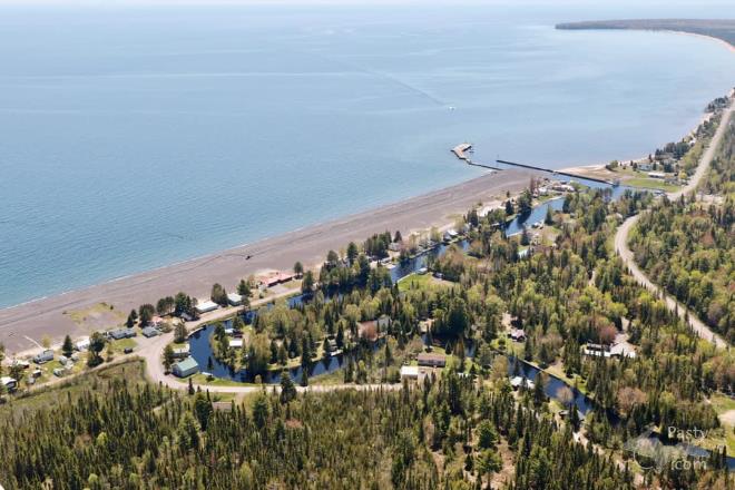
Town of Big Traverse    ...scroll down to share comments
Photo by E. Neil Harri
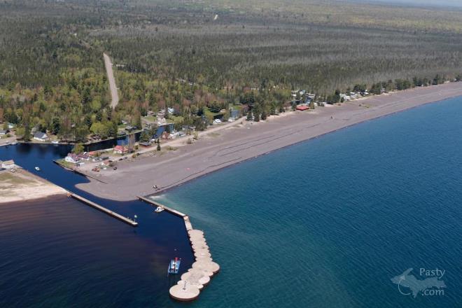
Big Traverse River into Lake Superior    ...scroll down to share comments
Photo by E. Neil Harri
Dr. Wm. Rose on the Stamp Sands    ...click to play video
See June 10 in the previous 21 years of the Pasty Cam
2018   2017   2016   2015   2014   2013   2012  
2011   2010   2009   2008   2007   2006   2005  
2004   2003   2002   2001   2000   1999   1998  

By
Mary Drew at Pasty Central (Mdrew) on Monday, June 10, 2019 - 10:09 pm:

The Gay Stamp Sands are once again beginning to plug the channel where the Big Traverse River flows into Lake Superior, so dredging is going on out there to move the sands by pump, to an awaiting pit further down the shoreline. E. Neil Harri shares a couple of photos he took this weekend of the process from the air. In the second photo you can see the pump lines running down the shore, along with the amount of stamp sand that has migrated to the channel, just about blocking it for some bigger boats.

This cleanup is necessary, not only to prevent flooding for the Big Traverse River residents, but also to protect the Buffalo Reef where Lake Trout and Whitefish spawn. Without that reef, the fish population in this area would be seriously affected. For more information click on this link: Saving Buffalo Reef

Today’s video was made by Keweenaw Now, back in 2014, when Dr. William Rose, Michigan Tech University professor emeritus (Dept. of Geological and Mining Engineering and Sciences), led a geo-tour on Michigan Tech’s research vessel Agassiz. He spoke about the movement of stamp sand (mining waste) in Lake Superior and on beaches near Gay, Michigan, on the Keweenaw Peninsula.


By Uncle Chuck (Unclechuck) on Monday, June 10, 2019 - 11:36 pm:

Will the powers that be ever act on the proposals to take care of and correct these adverse affects of the stamp sand? Where is the funding going to come from? It's a serious problem that is not going to go away, it's going to only get worse it appears!


By D. A. (Midwested) on Tuesday, June 11, 2019 - 12:00 am:

I'm pleased to see this is getting more attention than it has in the past. Simple periodic dredging of the river was all that has usually happened.

The video was taken during the annual MTU Geo- Heritage Tour in 2014. I took the tour in 2016 and I cannot recommend it enough. It is still being organized by Doctor Bill Rose and his MTU students and co-faculty. In addition to covering the mining history and it's impacts, they also cover the Jacobsville Sandstone, the Keweenaw Lava Flows and the Keweenaw rift and all the associated fault lines (which create all the wonderful waterfalls).

I have 4 different Pasty Photo Galleries of the MTU GeoHeritage Tours.

This is the one specific to the Pasty Photo Galleries of the Mining Impact.


Powered by:  
Join Today!
You are welcome to comment here or on 
Pasty Central's Facebook page
Here's a list of messages posted in the past 24 hours
See our guest photo gallery for more great views from the U.P.

Add a Message


A user/password combination is now required to post messages to Cam Notes. Registration is free. Click here to register or maintain your I.D.
Username:  
Password:

Home | Pasty Cam | Contest | Order Now | Bridge Cam | Past-E-Mail | GP Hall of Fame | Making Pasties | Questions