Jun 13-20

Past-E-Mail: Cam Notes - 2020: June: Jun 13-20
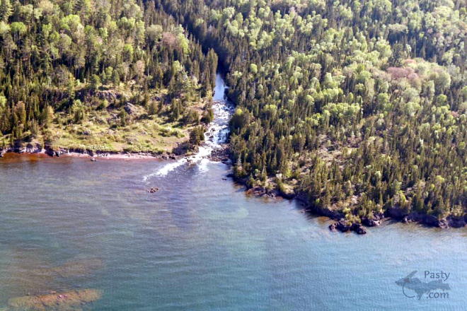
Mouth of the Montreal    ...scroll down to share comments
Photo by E. Neil Harri
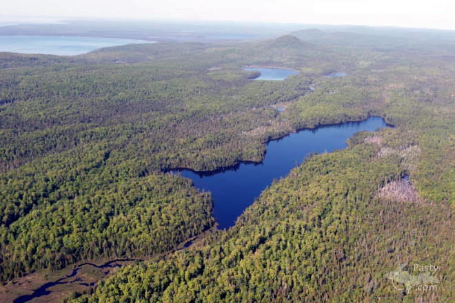
Lost Lake    ...scroll down to share comments
Photo by E. Neil Harri
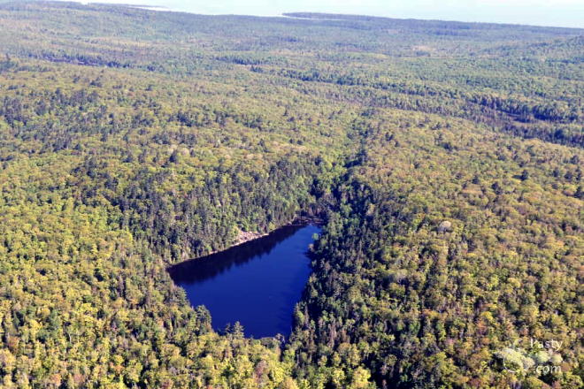
Breakfast Lake    ...scroll down to share comments
Photo by E. Neil Harri
Montreal Falls    ...click to play video
See June 13 in the previous 22 years of the Pasty Cam
2019   2018   2017   2016   2015  
2014   2013   2012   2011   2010   2009  
2008   2007   2006   2005   2004  
2003   2002   2001   2000   1999   1998  

By
Mary Drew at Pasty Central (Mdrew) on Saturday, June 13, 2020 - 09:55 am:

We started the week E. Neil Harri and we’re wrapping up the week with him, too, as he does a flyover of some places he thinks are worth a visit on the Keweenaw Point. He starts out at the mouth of the Montreal River, where it cascades down a falls and into Lake Superior. If you visit on foot, be ready to hike a little over a mile in to the Lower Montreal falls. If you’re feeling adventurous, you can hike up the river to the Upper Montreal falls, too, it’s about another half mile trail.

The second photo is Lost Lake. I couldn’t find any information for finding this lake, maybe that’s why it’s called Lost Lake, because you can’t find it. I was there once with friends on 4 wheelers. We had to walk in a short distance to the lake and it was beautiful. The friend who brought us there goes fishing there quite often. It was quiet and peaceful there.

The lake in the third photo is called Breakfast Lake. I’m sure we also visited this lake while 4 wheeling, too, but I don’t recall much about it. Both of these lakes can be accessed off the Mandan Road. Again, I couldn’t find directions to post here, but if you’re looking for adventure, I’m sure you’ll be able to find some locals in the area that can give you directions to find these “hidden” gems. Feel free to post directions if you know how to get to these places.

Today’s video was recorded by Douglas Feltman on a trip he made to the Montreal Falls in 2017. It gives a great view of the Lower Falls as it runs off into Lake Superior.


By Alex "UP-Goldwinger" (Alex) on Saturday, June 13, 2020 - 11:02 am:

Nice flyover, Mr. Harri and a very nice video, although I would have traded the music for the sound of the falls.!


By Uncle Chuck (Unclechuck) on Saturday, June 13, 2020 - 04:01 pm:

Fantastic aerial pic's Neil!! Thanks for
sharing.
I'm sure Marty and I have seen these lakes as
well
while out 4 wheeling in the truck, however, I'm
not sure how we got there either... it's easy to
get turned around out there off the High Rock,
Keystone, Mandan roads.... make sure you start
with a full tank of gas! lol

The video is great as well, but I agree with
Alex,
the music should have been the sound of the
falls!!


By D. A. (Midwested) on Saturday, June 13, 2020 - 04:33 pm:

Excellent review of Montreal Falls. I've never been up close but hope to someday. Given my health, I'll probably need a boat. I did see it by boat a couple of years ago but we only got within a couple hundred yards.

I hear'ya U.C.
My fondest memories of the Keweenaw wilderness are from the 1970's when I would wander around on foot. One weekend trip I made, after hitchhiking to Copper Harbor I walked in and spent a night all alone at High Rock Bay and another at Keystone Bay. I even "discovered" the rocket launch site before it had any signage. I remember thinking to myself, "This looks like you might be able to launch a rocket from here.", LOL. It certainly was not at all so "touristy" back then as it can be today. Last time I drove into High Rock a couple of years ago there were maybe 20 other people there.


By Deb S. (Usedtobeayooper) on Saturday, June 13, 2020 - 05:02 pm:

Yea, the music drowned out the falls. Without
it, it would have been much better. Neil's
pictures are wonderful, as always.


By FRNash/PHX, AZ (Frnash) on Saturday, June 13, 2020 - 06:07 pm:

Mary Drew at Pasty Central (Mdrew):
… The second photo is Lost Lake. I couldn’t find any information for finding this lake, maybe that’s why it’s called Lost Lake, because you can’t find it. …


Lost Lake: Found!
Lost Lake
47°25'45.4"N 87°49'08.5"W
47.429285, -87.819031


By FRNash/PHX, AZ (Frnash) on Saturday, June 13, 2020 - 06:20 pm:

Now let's see if I can get lucky and show a bit more detail in a larger image:
Lost Lake #1A


By FRNash/PHX, AZ (Frnash) on Saturday, June 13, 2020 - 06:23 pm:

Now a little closer in:
Lost Lake #2A


By FRNash/PHX, AZ (Frnash) on Saturday, June 13, 2020 - 06:42 pm:

The white streak above the lake from the upper left to center right starts out as Clark Mine Road for a very short distance then the remainder is Burma Road.

The white streak along the lower edge of the image is Mandan Road. Just where that road dips below the lower edge of the picture in the last image is a bridge over the Montreal River.

The white streak from center left almost to Lost Lake appears to be an unnamed road.


Mary Drew at Pasty Central (Mdrew) on Sunday, January 19, 2020 - 11:13 am:
FRNash...if you stick to the size that the original photos on the page are, you won't have any upload oopsies.
Original sizes are usually - 660 X 440 pixels, they can also be 660 X 495 or 495 X 660. The first number is your width, the second number is your height. Now you can "dood" it right every time!


Thanks for the tip, Mary. I dood it!
Powered by:  
Join Today!
You are welcome to comment here or on 
Pasty Central's Facebook page
Here's a list of messages posted in the past 24 hours
See our guest photo gallery for more great views from the U.P.

Add a Message


A user/password combination is now required to post messages to Cam Notes. Registration is free. Click here to register or maintain your I.D.
Username:  
Password:

Home | Pasty Cam | Contest | Order Now | Bridge Cam | Past-E-Mail | GP Hall of Fame | Making Pasties | Questions