Airport Information
From Google Maps
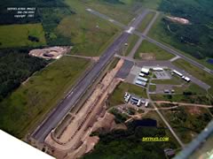
Provided by unknown
Airport Information
From Google Maps
Provided by unknown
Last update November 13, 2006
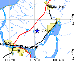
Location:
FAA identifier: CMX
Lat/Long: 47-10-06.3020N / 088-29-20.6190W
47-10.105033N / 088-29.343650W
47.1684172 / -88.4890608
(estimated)
Elevation: 1095 ft. / 333.8 m (surveyed)
Variation: 02W (1985)
From city: 5 miles NE of HANCOCK, MICHIGAN
Zip Code: 49913
Airport Communications
CTAF/UNICOM: 122.7
WX ASOS: 125.675 (906-482-4248)
* APCH/DEP SERVICE PROVIDED BY MINNEAPOLIS ARTCC ON FREQS 127.2/379.1 (HOUGHTON RCAG)
Nearby radio navigation aids
VOR radial/distance VOR name Freq Var
CMX at field HOUGHTON VOR/DME 112.80 02w
NDB namd Hdg/Dist Freq Var ID
GALEY 313/4.8 275 02W CM -.-.--
KOGM - Ontonagon County Airport (41 nm SW)
KSAW - Sawyer International Airport (66 nm SE)
KLNL - Kings Land O' Lakes Airport (68 nm SW)
KIWD - Gogebic-Iron County Airport (78 nm SW)
KEGV - Eagle River Union Airport (81 nm SW)
Business Name Contact
Houghton County Memorial Airport 906-482-3970
Where to Say, Hotels, Motels, Resorts, B&Bs and Campgrounds in area

Problems with the website may be sent by email to the club webmaster. Please put “EAA webpage problems” in the subject line. Thanks.
© 2006