Oct 08-19

Past-E-Mail: Cam Notes - 2019: October: Oct 08-19
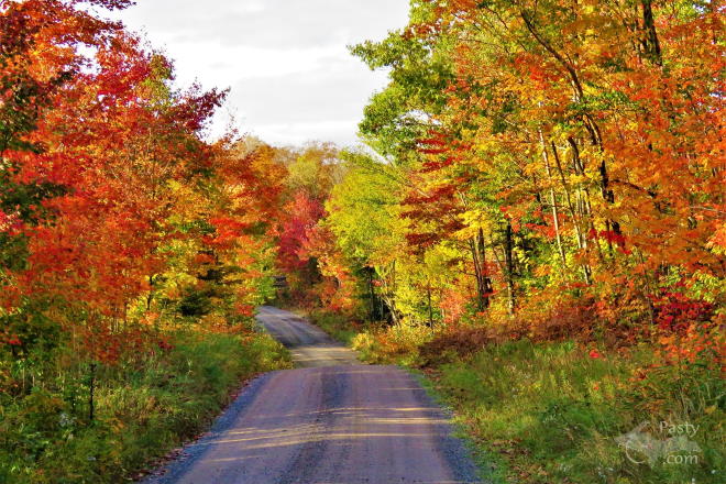
Dishno Road    ...scroll down to share comments
Photo by Nancy Haun
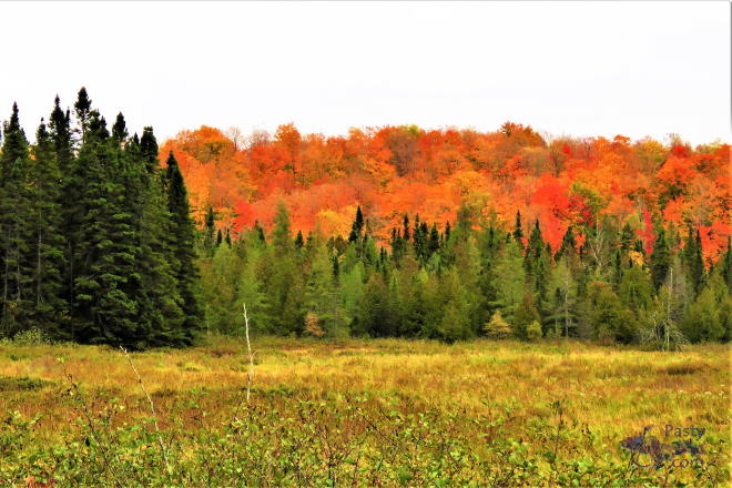
Peshekee River Marsh    ...scroll down to share comments
Photo by Nancy Haun
Four Beers Corner    ...click to play video
See October 8 in the previous 21 years of the Pasty Cam
2018   2017   2016   2015   2014   2013   2012  
2011   2010   2009   2008   2007   2006   2005  
2004   2003   2002   2001   2000   1999   1998  

By
Mary Drew at Pasty Central (Mdrew) on Tuesday, October 8, 2019 - 07:56 pm:

Nancy Haun traveled all over Baraga County backroads looking for color last week and she successfully found some beautiful hues. Her first photo was snapped along the Dishno Road off the Peshekee Grade. She said it’s a beautiful road with some gorgeous scenery and comes out on the Yellowdog Plains just shy of the Eagle Mine. Her second shot was taken at the Headwaters of the Peshekee River Marsh. Just look at that pop of orange color, WOW!

Nancy also made a video during her travels at the Four Beers Corner – aka -West Branch Huron River Road - and the Haypress Dam area - Headwaters of the Peshekee. I’ll have to take her word for it, since I have no idea where in Baraga County this is. Somewhere I may just have to explore some time.

We received a Press Release from the Calumet Theatre to share:

The Calumet Theatre is being featured in a segment of the Travel Channel's Most Terrifying Places series. It is all part of a month-long October programming promotion the national network calls Ghostober.
The premiere of the episode including the Calumet Theatre is Tuesday, October 8 at 10 pm eastern time. The episode title is Death Car which relates tales about (from the Travel Channel promotional material) “a menacing medieval castle, a terrifying train car straight out of a nightmare and a gilded opera house turned makeshift morgue, and are all the dire domain of the undead.” The Calumet Theatre would be the “opera house”.
Additional broadcast dates & Times are as follows (all times listed Eastern Time Zone):
Wednesday, Oct. 9 @ 2 a.m.
Sunday, Oct. 13 @ 3 p.m.
Tuesday, Oct. 15 @ 11 p.m.
Wednesday, Oct. 16 @ 3 a.m.
Saturday, Oct. 19 @ 11 a.m.
Tuesday, Oct. 22 @ 5 p.m.
Friday, Oct. 25 @ 1 p.m.

By
Deb S. (Usedtobeayooper) on Tuesday, October 8, 2019 - 08:12 pm:

Beautiful photos. I did see some color out here
in MN, but nothing like that. I wish we wouldn't
have missed peak. Oh well, there's always next
year.


By Uncle Chuck (Unclechuck) on Tuesday, October 8, 2019 - 10:34 pm:

Nice colors!!


By D. A. (Midwested) on Tuesday, October 8, 2019 - 11:02 pm:

Beautiful! If my boss had not scheduled annual meetings for next week I'd be sitting at the Ambassador tonight enjoying my favorite pizza.

The folks a NOAA finally got a clear satellite photo today showing the status of colors. They seem to be extending fairly well south.

2019-10-08


By Thomas Baird (Thomas) on Wednesday, October 9, 2019 - 04:28 am:

Beautiful!


By Alex "UP-Goldwinger" (Alex) on Wednesday, October 9, 2019 - 09:37 am:

I think I felt every calm feeling that Nancy felt while watching that video...thanks for the outing.


By Bob Williams (Wabbit) on Wednesday, October 9, 2019 - 11:09 am:

Nancy has a public facebook page with many pictures on it.
https://www.facebook.com/groups/264582390379491/


By mickill mouse (Ram4) on Wednesday, October 9, 2019 - 01:14 pm:

I love that video. Want to say, 'Thank You', Nancy, for that. If you ever make it out there again, make the video a little longer.....:O) Very calming.


By FRNash/PHX, AZ (Frnash) on Wednesday, October 9, 2019 - 05:01 pm:

Mary Drew at Pasty Central (Mdrew):
"… the Haypress Dam area - Headwaters of the Peshekee. I’ll have to take her word for it, since I have no idea where in Baraga County this is …"


The Haypress Dam? That was a new one for me as well, but Eureka, I found it!

From (click →) Waterfalls of the Keweenaw Area,
see (click →) Haypress Dam Falls on Pesheekee River.

Note the directions:


Quote:

"Take the Peshekee Grade north from US-41 (just east of Michigamee) for 14.8 miles. A small pull off will be on the right side of the road near one of the grade's rock cuts. Park here and follow the trail that leads down to the river."


To see this on Google Maps, plug this 46.68235 -88.12584 into the Google Maps Search box.

Four Beers Corner? I haven't found that one yet!
Powered by:  
Join Today!
You are welcome to comment here or on 
Pasty Central's Facebook page
Here's a list of messages posted in the past 24 hours
See our guest photo gallery for more great views from the U.P.

Add a Message


A user/password combination is now required to post messages to Cam Notes. Registration is free. Click here to register or maintain your I.D.
Username:  
Password:

Home | Pasty Cam | Contest | Order Now | Bridge Cam | Past-E-Mail | GP Hall of Fame | Making Pasties | Questions