While driving around this spring, as the roadways begin to dry out, and the stampsand is exposed, take the time to look in the rear-view mirror, and see how much dust you create in your wake.
From the New York Times: Tests have revealed elevated levels of benzo(a)pyrene, a carcinogen similar to the tar in cigarettes, and tricholorethylene, a widely used solvent that might be carcinogenic, in the soil around the school. But state health and environmental officials have said there is no way for students to ingest or inhale those chemicals, particularly with the ball fields closed as a precaution.
Let me preface this by saying that I was born and raised in Tamarack Mills, on Torch Lake, the depository of 20 million tons of tailings and chemicals from the smoke-stack spewing days of industrial copper mining. The blowing sands from the lifeless desert of tailings of Torch Lake plagued the summers of my youth in Tamarack Mills, a small town that hasn't seen more than five new houses built in the last 40 years. We were as much at the mercy of the dust of summer as we were to the snows of winter. In August 1997, the MDEQ collected a total of 50 surface soil samples from 11 locations in the Torch Lake area. These were all analyzed for metals, and a selected 9 samples were split for analysis for semi-volatile organic chemicals. The arsenic concentration in one sample, from the Quincy Smelter area, and the lead concentration in another sample, from the Tamarack/Mason Dredge area, exceeded the MDEQ Generic Clean-Up Criteria for Industrial, Commercial or Residential Use. Many other samples contained arsenic, benzo(a)pyrene, beryllium, or copper concentrations above the MDEQ Residential Use Criteria. The sample with the benzo(a)pyrene concentration above the Residential Criteria was collected from the Tamarack/Mason Dredge area (area C), those with beryllium above the Residential Criteria were collected from the Hubbell Slag area (area B) .[available at: http://cisat1.isciii.es/HAC/PHA/torch/tol_p2.html#discussion] No one is likely to ingest enough beryllium from the soils within the study areas to experience any non-cancer adverse health effects. Some laboratory animals who inhaled or ate beryllium compounds developed lung cancer more often than did animals who were not exposed to the metal. The concentrations of PAHs found in the soils of the study areas are within the range of concentrations typically found in urban areas. Benzo(a)pyrene and several other PAHs have been linked to cancer in workers who were exposed to them on the job and in laboratory animals who had the chemicals applied to the Based on the available information and data, the tailings piles pose no urgent
Hi Walt, the short answer to the question, what are Benthos is that they are the clams, snails and insects that live at the bottom of the lake. The next question is why are they important as a measure of the healty of the lake? Here are a few of the answers to this question.
I promised more late or more later, but I didn't realize I'd be back this quick. In the September, 2000 minutes of the Torch Lake Public Action Council, or the Torch Lake Area of Concern Public Action Council (I'm not sure, but I think the more politically correct name change happened before September): SEPTEMBER, 2000:
Enrichments! That's truly priceless. I guess the stakeholders intend to hold on to their share of the enrichments by hook or by crook.
|
Before some muddy-water sauger comes to spawn on my last post, allow me to down-load again:
Jeff,
There certainly do appear to be some Orwellian(or optimistic?) nuances in the vocabulary of the PAC from whom you quote, Walt. Do you know what particular "enrichments" the Superfund operation has been targeting for reduction(if any)?
You know, before I discovered the Torch Lake Public Action Council website, (the appellation: Area of Concern, formerly situated between Lake, and Public, was dropped from usage)I had faith in the people of this area to do something about the pollution of Torch Lake. But after reading some of the minutes contained therein, along with some of the other writing, I'm inclined to believe these concerned citizens, as some have called them, have less concern than I believed they had. The Torch Lake PAC consists of representatives of community "Stakeholders' who will work and coordinate with the US Environmental Protection Agency, the State of Michigan's Department of Environmental Quality and the International Joint Commission to plan and execute remediation of the Torch Lake Area of Concern through a capacity building process. The poor rock and stamp sand deposits contain elevated levels of copper, while the slag and associated sediments contain significant enrichments of not only copper but also arsenic, lead, chromium, and other heavy metals. Today, these sands or mine tailings are simply an unfortunate by product of the mining era. There are no contaminated deposits of up to seventy feet thick as has been claimed. Yes, some of the sands have accumulated over time and may be up to seventy feet thick. However, these sands are inert materials, contain no heavy or other metals in dangerous quantities. While the benthos of Torch Lake is not as healthy as it should be due to the decades of deposition of fine mine tailings, it is in a state of steady improvement and it is good enough condition to support a healthy and growing fish population. The USEPA has provided funds for the revegetation to take place. The shallow groundwater associated with OU II which has come into contact with stampsands (waste from copper ore milling) exhibits inorganic contamination which results in unacceptable potential future risks, however, these risks are only applicable if, in the future, the stampsands are developed for residential use and drinking water is taken from the shallow groundwater. The practice in the region is to drill drinking water wells into the sandstone aquifer which underlies the stampsands. Since the sandstone aquifer has been found to be unaffected by stampsand contamination, any future risk from contaminated groundwater is
The following message was just posted on the Enviro-Mich list.
A special Copper Harbor Utility Board meeting will be held at 9 a.m. on Friday, March 16, at the Community Building in Copper Harbor. Township Supervisor Ken Korhorn said the Utility Board plans to exchange information with contractor MJO concerning their request for extension of sewer services to MJO's proposed purchase and development of 270 acres at Hunter's Point. While two of the board members are out of town, Korhorn expects a quorum and representation by the DNR and The Nature Conservancy. The state (DNR) is reportedly interested purchasing the west end of the bay and Hunter's Point to preserve the natural view from the marina and keep the established trail intact. The meeting is open to the public. See March 10, 2001, article on www.keweenawtoday.com
I received the email alert from the Public Access group yesterday as well. It will be interesting to see how Grant Township officials and concerned citizens react to this proposed Hunter's Point development project by MJO.
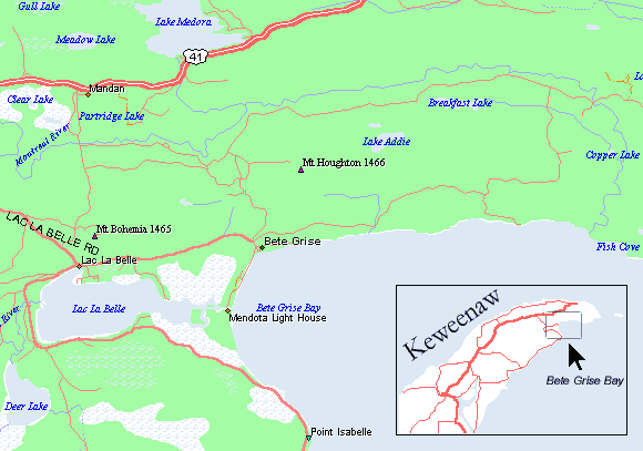
I wonder if it would be possible to see a map of the Copper Harbor/Devil's Washtub/Hunter's Point area of Keweenaw County here?
Walt if you go to Mt. Hougton from the Mandan road you will see the signs posted by the landowner. Heartland forest products. This was not a rumor. The ski runs were cut, still there and the suspected individuals denied there involvement when questioned by the DNR.
|
Where are Bete Gris North and Bete Gris South located on this map?
I forgot to add that the MNA trail(mistakenly labeled "Bare" Bluff) to Bear Bluff is about 1/8th of a mile past the point where Smith Fisheries road crosses over Bear Creek. You'll find a small parking area on the right just before the road veers left. There a 3/4 mile walk in to the loop trailhead. Take the clockwise route from the trailhead as there is a lot less chance of losing the path.
Bear Bluff is two miles directly south of Breakfast Lake, Charlie. About 100 yards north of the Lake Superior shoreline. It's the high area about 4 miles NE from the blacktop highway to Bete Gris that the Smith Fisheries Road curves north around in order to reach its destination.
Jeff and Anthony -
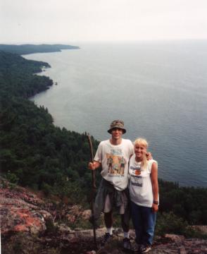
Anthony Wayne is right about the Bear Bluff shot. I took a very similar picture of Keweenaw Point last fall while standing upon the very same shelf of red rhyolite this happy couple is seen smiling. I recommend a visit to this Michigan Nature Association site for anyone without a heart condition.
Charlie, |
Walt,
By Walt Anderson on Wednesday, March 7, 2001 - 09:39 pm:
Did anyone else see the photo of Mount Houghton on the Pasty Cam? Who can explain that large white crescent of treeless mountain? I heard something over the summer about some cutting that had happened there on Mount Houghton. Is that crescent moon on Mount Houghton the result of what we heard about last summer?
ONE HECK OF A JOB COPPER KINGS !!!!!!!! GREAT WIN OVER HANCOCK 5-2. GOOD LUCK IN THE REGIONALS. REALLY PROUD OF ALL THE PLAYERS.
Robin Niemi here is a limk that might help find info about your grandmother.
Hi Robin,
Tommy Boy,
Any one up there have a book about the history of the Area that was made for a centenial celebration of some kind.I was told there is a picture in a book like this of My Grandmother Wilma Fraki.She was a school teacher in a one room school in either painesdale or south range.The picture would have been from the late 1910s early 1920s.The picture is supposed to be of her standing in a school room with the caption Miss Fraki under it.I would love to have a copy of this picture.Can anyone help!
Hey Lynn, where ya been? |