Aug 22-02

Past-E-Mail: Cam Notes - 2002: August: Aug 22-02
Taka's Dredge Report    ...scroll down to share comments
Photos by Taka Aoki
Group from Tech    ...scroll down to share comments
Photos by Taka Aoki
Mining era ruins    ...scroll down to share comments
Photos by Taka Aoki

By
Toivo from Toivola on Thursday, August 22, 2002 - 10:58 am:

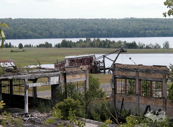
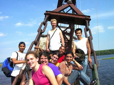
Oh boy. This will probably get me in trouble while Charlie's away. The PastyCam photobox received these shots from Taka Aoki, taken after the Summer Youth Program had ended at MTU. This is the same group of counsellors and staff who sat on the beach at midnight, watching Northern Lights over Houghton 3 weeks ago. Now they're back with a final adventure.

Charlie told me not to do anything controversial while he's on vacation, but I just had to pass along these shots (even though these guys were probably not supposed to be there). So now the debate will rage on: Should the Torch Lake Dredge be made an official participating site in the National Historical Park??

Touching history

By Temporary Troll on Thursday, August 22, 2002 - 11:30 am:

In as much as the dredge tells an important part of the copper mining history of the Keweenaw, it should of course be made a part of the KNHP. Too many vital parts of that history have already been lost. If making the dredge an "official" site will help to preserve it, what are we waiting for?


By John, MI on Thursday, August 22, 2002 - 11:47 am:

I agree. The dredge was vital for the operation.
They had to dredge the channel to get the boats in to bring the coal for the smelter and other operations. Toivo. No hot water for you on your choice for today. Charlie has used pictures of people on the dredge also. They might have shipped the balls they made at the foundry on the boats going out. I don't know that, but I'm sure the boats didn't go out empty. Anyone out there that would know that?


By JAD, Oskar, MI on Thursday, August 22, 2002 - 11:54 am:

Ditto! And the graffiti should stand as is. It is also a part of Copper Country history.


By Tim in Oscoda on Thursday, August 22, 2002 - 11:55 am:

I'm sure that Bill P. can help you out!


By 100% yooper on Thursday, August 22, 2002 - 12:11 pm:

The (2) dredges that are in Torch Lake had a very vital role in copper mining history, They were used for copper reclamation. It was found to be cost effective when the price of Copper dropped, but mine operation cost was up, to remove the copper that was left in the sands. In the photo that shows the dredge in the distance, the building you see had separators to remove copper from the sand dredged up from the lake. With that said, I feel it would be a mistake not to include them. (When I refer to the (2) dredges, as you drive by this site you could see the remainder of the other dredge sticking out of the water about 100 yds. from shore. Just North East of the one in photo.)


By Patrick, Grand Rapids MI on Thursday, August 22, 2002 - 12:11 pm:

John, the Dredge in the pcitures was not used to dredge out the channel to get boat up to the foundry. Thoes were a diffrent type of Dredge. This particular one was used to literally vaccum out stamp sand, which had been discarded into the bottom of Torch Lake by the Quincy Mine in over the years prior to the 1930's. They found as mining technology increased that it was more cost effective to go through a couple chemical process to get copper back out of the Stamp Sand that was discarded than to continue mining it. The Stastics are almost astounding, in all years of operation almost a third (and I don't remember the exact numbers) of the total tonnage of Copper was take out of the bottom of Torch Lake, by one of the three dredges that were used.

**If I have facts wrong, please correct me, but I belive this to be ture**

As for making this part of the National Historic Park, most deffinatley!! Great work Toivo!

Patrick in Grand Rapids, MI (Formerly of Marquette)


By Rich Karl, WI on Thursday, August 22, 2002 - 12:15 pm:

It is IMPERATIVE that the dredge be made part of the Park. The day is coming when those of us who have left the area will have little to show to new friends when we bring them up there, what with all the road closures, the idiotic dynamiting of historic Shafthouses (read: Kingston) and the general disrepair of old structures.

It is TIME to decide whether we want the Copper Country to be a Historic, Scenic area...or just another soulless tourist trap...

(sign me)
NEVER should have left


By John, MI on Thursday, August 22, 2002 - 01:35 pm:

Thanks for enlightening me Patrick. That's how I learn about the past, from others.


By Fred-lower Mi. on Thursday, August 22, 2002 - 02:29 pm:

Hello to you lucky people who live in an area with so much valuable history & beauty. I live in Midland Michigan & have been in your beautiful part of the state many times in the past 60 yrs. As a troll from the lower- I have some questions for you or someone who lives in the Houghton or Hancock area. Hopefully someone that has boated or Kayaked the Portage River. I and my neibor are planning to come up in Sept. of this year and camp and kayak the length of the Portage River.

A few questions if I may:
-Is there any current flow in this river, and if so- what direction.
-Do you know what if any places there are to stop and set up a pup tent for over-night. (we don't need power or anything) but don't know if it's all private land along the river length. we think it will take about 2 days to paddle it all.
-Is there a place to put in and take out at either end?
-We will probably use the state park as the starting point or ending point of the trip. ( we have paddling experience and our own boats)

Can't wait to get up to your part of the country again. It is so special- BUT we need your help on the above few points if we can. If you don't know the answers- You may be able to tell us were to send a note for help.

Thanks


By Julie from Novi on Thursday, August 22, 2002 - 03:10 pm:

As long as we are in that part of the Keweenaw, can someone tell us how to get to Hungarian Falls? We tried to find them by going up 6th street out of Tamarack City a couple weeks ago. However, we didn't see anything that was obviously a trail to the falls. We hiked it as kids 30 years ago but we couldn't find a clue this time as to where to start. Are they accessible?


By LIZ, Pinckney, MI on Thursday, August 22, 2002 - 04:06 pm:

Julie from Novi - I last hiked to Hungarian falls some 12 or 13 years ago with some guy named Ken. I don't remember how we got there though.......


By Sunshine on Thursday, August 22, 2002 - 05:18 pm:

I've been anxiously waiting for the pics of The Northern Lights to become "WOW" so I can have it as my wallpaper. I miss the lights & don't get to see them now that I live in Wisconsin. Please help!


By Paul in Illinois on Thursday, August 22, 2002 - 06:30 pm:

Hi,
The Quincy Reclaimation Plant was financed by the Metals Reserve Co. a Federal Agency, and was designed and built with the help of Calumet & Hecla who virtually invented the process in the Copper Country. It opened in November 1943 and closed in 1967 when the sands were exhausted. The ruins you see in the third photo are actually the floatation addition to Quincy's #1 mill and were added in the '20's. The Reclaimation Plant was located a little farther down the road towards Hancock. Both dredges were originally owned by C&H. The one that is totally sunk went down in a storm while Quincy owned it, this one was then purchased and was evidently either parked and sunk or was scuttled there. The main portion of the mill burned years ago. A friend of mine found a good sized chunk of silver among the cinders where the classifing tables would have been. This was some mill hand's stash that had melted during the fire.


By Jim MI on Thursday, August 22, 2002 - 07:12 pm:

Hi
The totally sunken dredge sank during the winter, or early spring, I remember the ground was snow covered pretty deep. It had just been overhauled the summer before. The dredge on the bank was purchased from C&H to be used while the number 1 dredge was being rebuilt, and after the loss of #1 it was used as long as reclamation was under way by Quincy.
Jim


By Meg. Michigan on Thursday, August 22, 2002 - 10:28 pm:

RE: Hungarian Falls...was there last week and the Falls were bone dry. Still gorgeous scenery though.


By Alice, Ventura, CA on Thursday, August 22, 2002 - 10:48 pm:

Yes to the historic site. And yes to all the information and education we get on this site! I wonder about the day when all of you out there won't be here any longer to fill in the history for those who want to know why or what something is. Right now there has always been someone out there, everytime, to answer the question, give related links and generally educate the rest of us on this wonderful place...the copper country. I hope that the legacy and history will be left for those who come behind us. Thanks all!


By Ken from da UP on Friday, August 23, 2002 - 12:06 am:

Yes, I think the dredge should be a part of the park. It was part of the mining industry there. There are three waterfalls up the hill from Hubbell/Tamarack City. The dirt road went to the left toward the creek. There was a C&H dam upstream from the falls where we used to swim. It's a good little hike down stream to the Papa Falls (the high ones). The other two falls are between the dam and the Papa falls. There used to be two railroad trestles (bridges) across Hungarian Creek. One C&H and one Copper Range or Mineral Range track. You could really get a nice view of the falls from the middle of the upstream one. That was then, this is now. :o( That road was about 1/2 way between the old railroad crossing and the corner that goes right (toward the Calumet Golf Course). Good luck!


By Taka on Friday, August 23, 2002 - 03:10 am:

The dredge has been a famous place not only as a historical building, but also as a cliff diving spot (not exactly "cliff" of course. Believe or not, they jump off the top of the iron frame). People also like to visit this place for fishing.

Is that only me who is feeling the building is tilting every year? It is best to make the dredge a part of national park asap before it tips over.


By Chris Colvin, FL on Friday, August 23, 2002 - 09:05 am:

Wow! I have my own pictures of the dredge, although I wasn't daring enough to climb aboard. Last summer I took a trip back to the UP to visit my hometown of Marquette and made the dredge one of my "must-see" locations.


By Jussi, On the hill on Friday, August 23, 2002 - 11:01 am:

Toivo Valmis te hankkia hankaluus ehtiminen että Nash Rambler alku nyt kuluva aamu?

Ja kuinka aari te nyt kuluva aamu Candy?

Sen ehtiminen alakuloinen kotona lännenpuoleinen. aurinko jälkisäädös olla rikki aikaisin.


By Chris in Redondo Beach on Friday, August 23, 2002 - 11:53 am:

Ah, brings back memories of my days as a tour guide at Quincy Mine. I spent two summers doing that and loved it. Who are the people in the picture? I thought I recognized a few local faces but it was hard to tell. Were they all out of towners just visiting the place?


By 100%yooper on Friday, August 23, 2002 - 12:09 pm:

Hungarian falls,

Go up 6th street, left at the fork, you come to the first rail crossing which goes to the trestle, go past this one. At the second rail crossing go left to the creek, there is an old trail system to the falls which splits into an upper and lower trail. If you want to start at the pond and work your way down, go to the third rail crossing and go left to the pond.

Hope this helps, though this time of year the falls are usually pretty dry.


By Candy, CA on Friday, August 23, 2002 - 12:15 pm:

Good morning, Jussi -- I'm just waking up out here in CA. I frequently drove the "lower" road from Hancock to Laurium and have fond memories of the dredges and old mining buildings. I hope to see them at least shored up, if not restored, as wonderful additions and amplifications to the Park.


By Skylar Baxter Oxford, WI. on Friday, August 23, 2002 - 01:23 pm:

We were in the Keweenaw last month. I wanted to get to the dredge but, the chain link fence kind of swayed our decision. Not being a local, I did not want to get in any kind of trouble, and possibly ruin it for other people. I think that it should be part of the park also. Later, Skylar.


By Rose, UP on Friday, August 23, 2002 - 01:51 pm:

To Julie from Novi: Hungarian Falls

Just to clarify on 100% Yoopers comments: the 3rd railroad crossing now has an orange gate across it. It will be on your left as you go uphill. This is the easiest walking, since you are largely staying on flat ground. If you go in at the 2nd railroad crossing, you have a stiff up-hill climb. But if you want to go down to the bottom of the large falls and see it from below, you need to go in at the second railroad crossing and climb down a steep hill.
If you walk in at the gate, you have to turn left and go downstream to see the largest falls. The Middle Falls is also very lovely on this same walk. If you turn right and go upstream past the impoundment, you see what I think is the prettiest falls in the series, the Upper Falls. Nothing is more than a 1/2 mile walk from the gate.
Enjoy!


By Gary @ Rice Lake on Friday, August 23, 2002 - 03:25 pm:

The top of the sunken dredge in Portage used to be visable. Did not notice it this summer. Was it removed or finally rusted away


By Fran,Ga on Friday, August 23, 2002 - 06:33 pm:

The dredge should definitely be restored or at least shored up and painted so it would appear like it did all those years when our friends and relatives worked there.Too many of the buildings have been lost forever. As a child I remember. going by there at night and seeing it all lit up and operating and it fascinated me. I know people would be interested in the history of it. This information needs to be recorded while the older folks who remember are still here.


By Missing the up, lower MI on Friday, August 23, 2002 - 09:24 pm:

I feel that they need to take the gates off from around the dredge. Some of my best childhood memories are playing on the dredge, yes I know that was dangerous but that is what being a kid is all about. I feel if it is made an "attraction" it will actually take away from the beauty and the history of it. Leave the dredge alone but still allow tourists to view and enjoy. The best part of going to the dredge is climing on it. If you fall that is your own problem. So they should just put up a sign to warn people of this. Also if they want to restore one why don't they pull the one out of the lake that is actually more of a hazard to boaters. Most likely its in better condition, no grafity or missing pieces. I am sure people take parts of the dregde as souvenirs.


By Stan Kotajarvi, MI on Tuesday, August 27, 2002 - 02:10 pm:

To Fred:
I'm surprised that someone hasn't already corrected a minor misconception. The body of water you speak of is Portage Lake. It is not a river. Originally it was a long skinny arm of Portage Lake that had only one outlet into Keweenaw Bay at the eastern end . In the late 1800's when shipping became important, a canal was dredged at the western end to connect to Lake Superior (a distance of about a mile) so that ore boats could cut off the miles going all the way around the Keweenaw point. It was also safe water in stormy weather.
As for camping, you already know about McLain Park at the western end, but the only other public camping I know if is at the Hancock City Camp Area about 1/3 of the way from the western entry. So far as I remember, there is only a slight current in these waters, but I think it ran west to east.
The whole distance from Lake Superior on the west to Keweenaw Bay on the east is only about 20-25 miles. If you don't stop too often to sight-see, you could do it in a day--but whose in a hurry?
If I were going with you it would take at least a month. Have fun!


By Ellery, who ALWAYS over-researches vacations on Wednesday, August 28, 2002 - 01:09 pm:

In answer to Fred's earlier question (just getting around to late last week's mail from Pasty Cam). Hope this is not too late (or one too many) a response. To find out more about the Keweenaw Water Trail, you should visit: http://www.exploringthenorth.com/chassell/watermap.html . There are maps, descriptions, & contact info for the KWTA. & just in case the site doesn't open for you, here is the contact info.
Keweenaw Water Trail Association
c/o Keweenaw Tourism Council
326 Shelden Avenue
Houghton, MI 49931
906-482-2388 or 906-338-7982

Hope this might be useful for others as well.


By Peter Kettenbeil Qc. on Thursday, August 29, 2002 - 08:14 am:

As per the question on the current in the Portage Lake/Canal....it changes direction in Dollar Bay approx.every 15 minutes in the channel at Sandy Bottom park.....When we were kids depending on the phase of the moon & high/low pressure systems it was quite strong...

It did the same thing in the "cuts" between Torch Lake & Portage.....

Can anyone out there explain how this works?


Powered by:  
Join Today!
Messages can no longer be posted to these older discussion pages, but you are welcome to join the conversation on Today's Pasty Cam

Here's a list of messages posted in the past 24 hours

See our guest photo gallery for more great views from the U.P.

While in the Copper Country be sure to visit
On US-41 north of Calumet
on US-41 in Kearsarge, a mile north of Calumet.
(The home of Pasty Central)

Home | Pasty Cam | Contest | Order Now | Bridge Cam | Pasty.NET | GP Hall of Fame | Making Pasties | Questions