By Mary Drew at Pasty Central (Mdrew) on Monday, July 7, 2014 - 10:55 am:
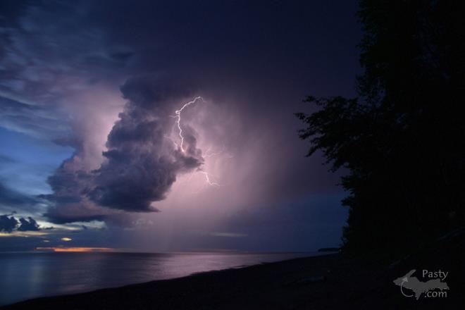
Today's photos and narrative come to us from Brad Uren, who was overlooking Lake Superior, out at Sedar Bay during one of our recent thunder and lightning storms. He described all that was taking place so well, I didn't think I could improve on it, so here's what he had to say�
"On the evening of June 29, after a long warm summer day, a line of scattered storms moved across the Keweenaw Peninsula. Several of these cells were very energetic, producing a lot of lightning and one released large hailstones of up to 1/2 of an inch in diameter.
After the initial line of storms passed over Sedar (Cedar) Bay, I continued to hear thunder getting louder. A quick glance west over the lake revealed an isolated storm just offshore. This cell moved slowly off shore, eventually crossing over land miles north of my location. For nearly 45 minutes, I attempted to capture what I was seeing.
In the last photo, you can see the Marquette radar still shot, from that evening. That small spot just west of the Houghton-Keweenaw county line is the storm that I photographed.
The other photos capture some of the lightning show from that evening. Conditions were perfect for photographing the storm. It was distant enough to allow photos of much of the cell. It also provided some measure of safety as there were no storms or lightning directly overhead while photographing the action. The sun had gone down, adding an orange glow to the horizon below a deep blue sky of twilight. The lightning occasionally took on a purple hue, as seen in some of the photos. In others, it was a brilliant white that reflected off the wet rocks on the beach."
Since that evening�we've been having numerous thunder and lightning storms, with some high winds and heavy rain. Thanks, Brad, for sharing the photos and your narrative, too. You sure made my job easy today!


