Aug 01-12

Past-E-Mail: Cam Notes - 2012: August: Aug 01-12
Regrowth    ...scroll down to share comments
Photo by Tim Haas
Knocking on the door    ...scroll down to share comments
Photo by Brenda Leigh
Rainbow Lodge remains    ...scroll down to share comments
Photo by Brenda Leigh
Stop sign near Chapel    ...scroll down to share comments
Photo by Brenda Leigh
Remains of Two-Hearted Chapel    ...scroll down to share comments
Photo by Brenda Leigh
Bridge intact    ...scroll down to share comments
Photo by Brenda Leigh


By
Mary Drew at Pasty Central (Mdrew) on Wednesday, August 1, 2012 - 08:04 am:

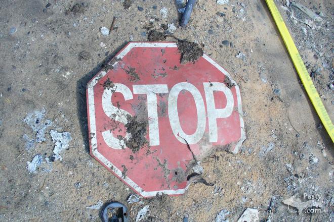
When I received the following email and the top photo here, from Ellen Haas, taken by her husband, Tim Haas, I knew an update on the Duck Lake Fire was something you all would be interested in. The remaining five photos come from Brenda Leigh.
Here's what Ellen had to say in her email:

We thought your visitors would like to see what is happening in the fire area.

As background, my husband and I are officers with the Superior Shoreline Chapter of the North Country Trail Association. Our section begins at the mouth of the Two Hearted River, hugs the shore of Lake Superior and eventually ends 20 miles to the west of Munising.

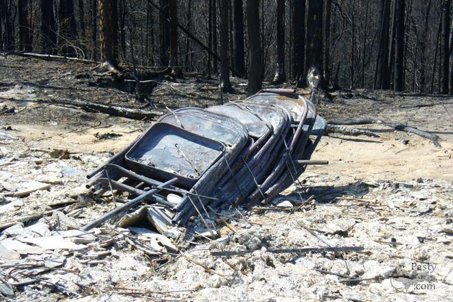
On May 24, 2012, the Duck Lake fire began at 3:50 p.m. and by 11:15 p.m. on that same day, reached Lake Superior. It is estimated that the temperature reached 3000 degrees. We lost several miles of trail.

We sat glued to our computers until it was over. On June 11, 2012, we were allowed in to inspect the damage. We knew the Rainbow Lodge had not survived, but it wasn't until a few days before we went in that we had visual proof that the suspension bridge was undamaged.

We made the decision to close the trail, the DNR agreed and furnished the signs. My husband has made additional trips in and some re-marking has begun. It is hard to put a blue blaze on a tree when there aren't any. Hundreds are down and some are still falling. Huge caverns are everywhere caused by burning stumps and roots.

There is some hope. I have attached a picture taken about two weeks ago. In addition to ferns, small trees are appearing. The odd thing is that they are Oak trees and we don't think we had any before the fire. On one trip my husband saw acorns but we assumed they were a Chipmunk "stash."
Note the last photo from Brenda here today, you can see up the river where the fire line is. At this point it burned to the lakeshore. It also burned the back of the campground but most of the campground survived. Thanks so much for the update, Ellen and the additional photos, Brenda. It's nice to see that even though everything is charred, the re-growth is taking over and starting to make things green once again.
By
Deb S. (Usedtobeayooper) on Wednesday, August 1, 2012 - 08:09 am:

What devastation! Nice to see the ferns growing back. To me, ferns so represent the UP. Love them!


By Janie T. (Bobbysgirl) on Wednesday, August 1, 2012 - 08:22 am:

So sad to look at, but in a way it is Nature's way of erasing and making a fresh start.


By Charlotte, Mishawaka, IN (Charlotte61) on Wednesday, August 1, 2012 - 08:54 am:

Glad to see an update after the fire. We were at Crisp Point on July 3rd. The drive in was past areas that burned. So sad to see the trees destroyed. Was thinking of the wildlife we've seen thru the years of going to Crisp Point and the campground at the mouth of the Two Hearted. Hope they all made it to safety and are doing well. Mother Nature can be both beautiful and brutal. Thanks to Ellen, Tim and Brenda for sharing the pictures with us.


By Alex "UP-Goldwinger" (Alex) on Wednesday, August 1, 2012 - 09:04 am:

That was a close shave for the house/cabin in the second pic. It looks like the flames were tickling the bottom right corner.


By Donna (Donna) on Wednesday, August 1, 2012 - 09:17 am:

Wow...and I'm with Janie..Mother Nature wanted to start over and she sure is...love the ferns showing their Yooper toughness~


By Gary W. Long (Gary_in_co) on Wednesday, August 1, 2012 - 09:19 am:

It’s hard to tell from just that second photo, but I wonder if firefighters were present as the fire approached the building. From the amount of charring on the siding, it looks like it would have certainly been consumed by fire without suppression efforts.


By allen philley (Allen) on Wednesday, August 1, 2012 - 09:39 am:

Almost weird how the cabin survived with fire at it's walls yet the Rainbow lodge is gone and there is no sign of fire up near it. Mother nature usually takes care of her self pretty well after these events. Except to protect private property its almost a waist to spend all they did. Sad about the church.


By Paul H. Meier (Paul) on Wednesday, August 1, 2012 - 10:42 am:

There is an old burn area just south of Lac la Belle. Probably from the '40's 0r '50's. Although new growth trees are now starting to take over, it has always been a great spot for wild blueberries. Nature recovers. Now with 20/20 hindsight, the Forrest Service is rethinking their stop every burn policy.
I was stationed at Ft. Carson in 1970/71. The area of the worst losses during the recent Colorado Springs fire was all second growth timber and "protected" by the US Forrest Service. About the only brush removal etc. allowed was my Combat Engineer company would cut Christmas trees for the post and charities. 40 years later there were houses in the "bush". Sad loss for the people that built there.


By Cindy, New Baltimore, MI (Cindy) on Wednesday, August 1, 2012 - 12:31 pm:

Charlotte, was everything okay at the lighthouse at Crisp Point? I'm thinking of making a stop there in September when we head up to the U.P.


By Doug Walters (Dawalters) on Wednesday, August 1, 2012 - 12:42 pm:

Cindy, We were at Crisp July 16th. All was good. They seem to always be adding some updates and the road out there while long is so much better than it use to be. Just a few flies that were biting that day. September should be great.


By Thomas Baird (Thomas) on Wednesday, August 1, 2012 - 03:13 pm:

Those ferns are a good sign that nature, through God, will restore the natural beauty.


By Shirley Waggoner (Shirlohio) on Wednesday, August 1, 2012 - 06:24 pm:

Nicely stated, Thomas, and I agree!


By Cindy, New Baltimore, MI (Cindy) on Thursday, August 2, 2012 - 06:19 am:

Thanks for your post, Doug. I'm glad everything at Crisp Point is okay. I haven't been there in several years, and I'm also glad to hear that the road is improved. I remember how bad the road was and how few signs there were then.


By Brenda Leigh (Brownmoose) on Thursday, August 2, 2012 - 12:12 pm:

It was a very sad trip back to this beautiful area to see the end result of this disastrous fire. Several of my friends and I had hiked 23 miles of this area six days before the fire started. I knew it would be eerie to return here. My husband and I could not believe the loss to this gorgeous area. We too were so happy to see that the brige over the Two Hearted River was still entact as someone on FB stated the bridge had been burned. So that was refreshing to see it still in place. Yes, the forest will grow back but in our lifetime and our childrens one will never see those hundred year old trees.


Powered by:  
Join Today!
Each day the Pasty Cam has 2 areas to post messages: 
  • Cam Notes - comments related to today's picture and discussion
  • What'sUP - other topics, conversation and announcements
  • *** Please use the appropriate forum ***
    Here's a list of messages posted in the past 24 hours
    See our guest photo gallery for more great views from the U.P.

    Add a Message


    A user/password combination is now required to post messages to Cam Notes. Registration is free. Click here to register or maintain your I.D.
    Username:  
    Password:

    Home | Pasty Cam | Contest | Order Now | Bridge Cam | Past-E-Mail | GP Hall of Fame | Making Pasties | Questions