July 29-05

Past-E-Mail: Cam Notes - 2005: July: July 29-05
Green rocks    ...scroll down to share comments
Photos by Joseph Hurley
Legend    ...scroll down to share comments
Photos by Joseph Hurley


By
Mary Drew at Pasty Central (Mdrew) on Friday, July 29, 2005 - 07:02 am:

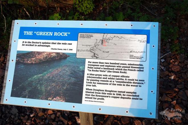
Now, I cannot count the number of times I've been to Copper Harbor, but these photos by Joseph Hurley definitely have me stumped as to whereabouts they were taken up there. Quite an interesting story about these 'green rocks', leading one to surmise that's the reasoning for the naming of the town. Here's what the sign reads, just in case you can't quite make out the story printed on it:

For more than two hundred years, missionaries, voyageurs and explorers who passed the Keweenaw Point noted a landmark which the French called "La Roche Verte" (The Green Rock).

A blue-green vein of copper silicate (chrysocolla) and white calcite, it could be seen by passing vessels at a "considerable distance." Look for remnants of the vein in the water to your left.

When Douglas Houghton tested samples blasted from this vein in 1840, he concluded that the Keweenaw's copper deposits could be mined for profit.

Just think the town could have been named Green Harbor, instead of Copper Harbor! :->
By
Patrick McKenney (Mckenneyp) on Friday, July 29, 2005 - 07:50 am:

I to am interested in where this is at as I have not come across it either. Please some one share. As we will be up there in 2 weeks.


By jmac (Jillann) on Friday, July 29, 2005 - 08:29 am:

I too would love to know the specific location, but I need it sooner than McKenneyup as we leave Sunday morning to begin our journey to Copper Harbor.


By Dan Brown (Danbrown) on Friday, July 29, 2005 - 08:30 am:

This is remnants vein of chrysocola, on Hays Point, a little northeast of the Copper Harbor lighthouse. Douglass Houghton made mention of it in his travels, and all those who passed by were able to see it even far off in the water.

Folks found this to be very curious, and some thought that this was what was to be sought when mining. Before these speculators had taken most of it away, it was nearly 10 feet across, and stretched "several rods" out into the lake.

Nevertheless, this tipped off the beginning of the Keweenaw's copper fever.


By Matt Adair (Mladair) on Friday, July 29, 2005 - 08:32 am:

They're on the interpretive trail out by the Copper Harbor Lighthouse.


By maija (Maijami) on Friday, July 29, 2005 - 08:37 am:

Interesting! I understand there is a massive amount of copper in veins running under Lake Superior.

Read once (maybe in Boom Copper?) of an effort to dam off the Lake in order to mine, but Superior won.


By Margaret, Amarillo TX (Margaret) on Friday, July 29, 2005 - 08:41 am:

Beautiful feature


By Patrick McKenney (Mckenneyp) on Friday, July 29, 2005 - 09:10 am:

Ahhh... the Interpretive Trails at the Light House... We havn't done thoes, been to the light house not the trails... Maybe I'll add that to the 'possibilities' list for vacation. Thanks.


By Stuart Crewdson (Stuyooper) on Friday, July 29, 2005 - 10:02 pm:

I wonder how much copper is in that vein.


Powered by:  
Join Today!
Each day the Pasty Cam has 2 areas to post messages: 
  • Cam Notes - comments related to today's picture and discussion
  • What'sUP - other topics, conversation and announcements
  • *** Please use the appropriate forum ***
    Here's a list of messages posted in the past 24 hours
    See our guest photo gallery for more great views from the U.P.

    Add a Message


    A user/password combination is now required to post messages to Cam Notes. Registration is free. Click here to register or maintain your I.D.
    Username:  
    Password:

    Home | Pasty Cam | Contest | Order Now | Bridge Cam | Past-E-Mail | GP Hall of Fame | Making Pasties | Questions