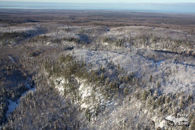
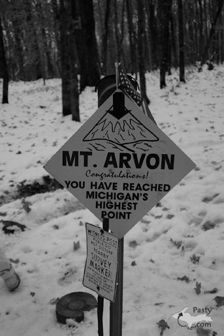
E. Neil Harri was recently flying above the U.P. and as he passed over the L'Anse area, snapped a picture of Mt. Arvon, the highest point in Michigan. That's quite the expanse of countryside, with a view of Lake Superior off in the distance there, too. The second shot is actually from the Archives and first appeared on 11/22/02, snapped by Jon Hopper, and shows the signage you'll see, should you venture to the top in person. Note the smaller of the two signs, which says: "Witness Post - Please do not disturb nearby Survey Marker...".
Today's third photo from Keith Meyers gives us a glimpse of that Survey Marker, minus the snowcover this time of year. It bears the U.S. Dept. of Interior logo, along with the year the marker was placed there (1982), declaring Mt. Arvon to be the highest point in Michigan, at 1979 feet above sea level.
If you'd like to read more information about the controversy when nearby Mt. Curwood was declared the highest point, then Mt. Arvon reclaiming the title, along with other pertinent information about the location of both of the mentioned mountains and how to find them, click on over to the archived page back in November, 2002.
By Alex "UP-Goldwinger" (Alex) on Monday, December 28, 2009 - 08:11 am:
Nice photos...this is on my list of future hiking trips.
By Bob Williams (Wabbit) on Monday, December 28, 2009 - 11:25 am:
I read the archived page. I have also heard that neither is the high point any longer. The new high point is supposed to be one of the rockpiles at either the Tilden or Empire mines. I forget which one.
By mickill mouse (Ram4) on Monday, December 28, 2009 - 11:40 am:
The first picture is absolutely beautiful. 'Thank You' Neil.
By E. Neil Harri (Ilmayksi) on Monday, December 28, 2009 - 12:06 pm:
I don't think the Tilden rock piles are the highest point. Maybe in the future but even then, they are spreading out more than getting higher.
By Helen Marie Chamberlain (Helen) on Monday, December 28, 2009 - 12:55 pm:
The lowest point in Colorado is the Arkansas River at 3315 feet above sea level, which is 1336 feet higher than "Mt." Arvon. I'm not sure if that is on the suface or the river bottom. I guess you'd either need a boat, wait until it's frozen, or else get wet if you went there.
By Shirley Waggoner (Shirlohio) on Monday, December 28, 2009 - 02:34 pm:
Interesting 'point', Gary!;) BTW, I love your state (CO).
By Thomas Baird (Thomas) on Monday, December 28, 2009 - 03:12 pm:
I always figured that if I owned property on Mt. Curwood & wanted my mountain to be higher, I'd just carry a bag or two or soil to the top & extend the height of my mountain by a foot.
By John Preisler (Jpreisler) on Tuesday, December 29, 2009 - 07:34 am:
It's fun to find those survey markers. I've only ever seen them in Michigan, but they're all over the U.P.
By Andy Larsen (Andylphoto) on Wednesday, December 30, 2009 - 10:19 pm:
No...none of the Cliffs rock piles are the high point. I spoke several years ago with one of their engineers. A large part of his job is researching and planting vegetation on top of the piles. This helps to stabilize, keep dust down, and provides habitat for wildlife. Interestingly, one of the things they do is use "paper sludge," a waste product from the local paper mills. It would otherwise have to be landfilled, but they dump it on top of the piles, and it ends up providing a very good growing environment for grasses & shrubs.
Anyway...strange as it may seem, the mining company doesn't want "high pointers" showing up to climb their piles. So to make sure that doesn't happen, they top them off about 50 feet LOWER than Mount Arvon. The other thing that he said they are doing recently rather than piling the waste, is using it to fill in the pit at Empire in areas they are no longer actively mining. Interesting stuff.
By Robert - CO (Halork) on Thursday, December 31, 2009 - 03:46 am:
Hi Gary -- Re: Colorado's lowest point -- you've got the elevation right, but it's the Arikaree River along the eastern border, not the Arkansas. The Arkansas used to be recognized by the USGS, but is not consistent with even their own maps. Sleuthing details here: http://www.usends.com/Explore/Elevations/Arikaree/index.html
By E. Neil Harri (Ilmayksi) on Friday, January 1, 2010 - 10:34 am:
I am writing this as a postscript to comments. I flew over the mine pits a couple times on my way to Sawyer, since the picture was posted.I can confirm what Andy said as I saw trucks dumping into the old pits. I also can confirm that it is below height of Mt Arvon.
By Lois Haglund (Thefinnishline) on Sunday, January 3, 2010 - 05:40 am:
I forgot where the government website is that shows elevation ... several years ago, I had found out that the high point on my property (& others around here, (Crystal Falls) is over 1500 feet. LOIS AT CRYSTAL FALLS
Powered by:
Each day the Pasty Cam
has 2 areas to post messages:
Cam
Notes - comments related to today's picture and discussion
What'sUP
- other topics, conversation and announcements
***
Please use the appropriate forum *** Here's
a list of messages posted in the past 24
hours See our guest
photo gallery for more great views from the U.P.