Apr 04-08

Past-E-Mail: Cam Notes - 2008: April: Apr 04-08
Leading the way    ...scroll down to share comments
Photos by Taana Kalliainen
Reaching the top    ...scroll down to share comments
Photos by Taana Kalliainen
View down below    ...scroll down to share comments
Photos by Taana Kalliainen


By
Mary Drew at Pasty Central (Mdrew) on Friday, April 4, 2008 - 05:36 am:

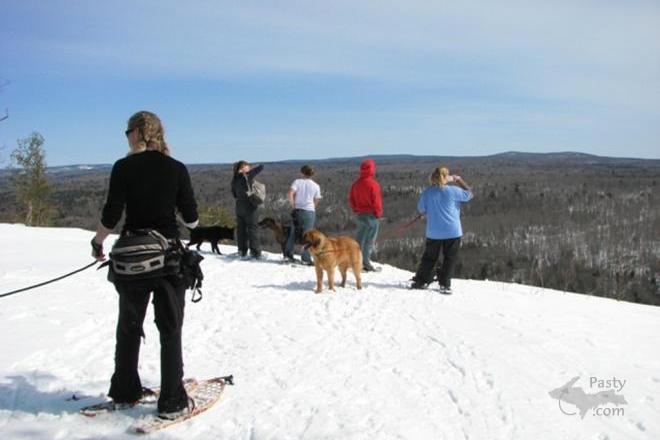
Looks like a pack of wild dogs on the loose, doesn't it? Well, they are a pack and they are loose, but they actually belong to Taana Kalliainen and a group of her friends that recently made a trek to the top of the Cliffs on Cliff Drive. There were 8 people and 8 dogs on this snowshoe journey to get up high, where they could enjoy a vista of the surrounding area. By the looks of their attire, they must have worked up a sweat and shed a few layers along their way, too. The third photo is just a sample of the views you get from atop those Cliffs. Can anyone supply some details of the scene laid out before us?


By kosk in Toronto (Koskintoronto) on Friday, April 4, 2008 - 06:50 am:

When my daughter was "snowed in" in National Mine (outside of
Ishpeming) earlier this week, she found snowshoes an excellent
way to get around with her two dogs on the back 40. From the
sound of things though, the big melt is on there just as it is here in
Toronto.


By Janie T. (Bobbysgirl) on Friday, April 4, 2008 - 07:01 am:

Looks to have been a great time for friends and dogs!


By John W Anderson (Wd8rth) on Friday, April 4, 2008 - 08:03 am:

My guess?? the third picture is of M-26 to Eagle River


By Capt. Paul (Eclogite) on Friday, April 4, 2008 - 08:09 am:

Not sure what details of the scene you want to know Mary?? Looking at the third pic, the 2 clearer areas on the left side of Cliff Drive behind the tree appear to be Cliff Mine. The small clearing on the right side almost centered in the picture would be South Cliff Mine. Off in the distance should be Phoenix in front of the far cliffs, and if you look very closely, you can see the Lake in the far distance over the cliffs. The cliff itself is the backside, or ramped-up side, of the massive Greenstone flow. If you could stand up there and see the entire landscape, you would notice how gradually the hillside rises away from the Lake then drops off sharply at the cliffs, just like a ramp. A great opportunity to see these “ramps” is on top of Brockway; they stick out like a sore thumb!!


By Alex "UP-Goldwinger" (Alex) on Friday, April 4, 2008 - 08:15 am:

Excellent photos...does anyone have any hiking trail information for this location?


By John W Anderson (Wd8rth) on Friday, April 4, 2008 - 08:20 am:

I'm going to change my guess, I missed reading they where off of cliff drive. I'm going with Capt. Paul


By Deb S. (Usedtobeayooper) on Friday, April 4, 2008 - 08:30 am:

Looks like a great time. What a view!!!


By William M. Jacka Sr. (Bama) on Friday, April 4, 2008 - 08:58 am:

You are west of the CLIFF HILLS that are within acouple of hundred yards of the intersection of US41. At this point you can view the CLIFF BAR< Vansville and 4i coming down from the snow gauge. At this poibt all you see is the Cliff Road. Look in back of the tree. We did get to the top this winter on snowmobiles spectacular. These folks are about 1.5 to miles west of the CLIFF ROAD and the intersection of US 41.


By Brooke (Lovethekeweenaw) on Friday, April 4, 2008 - 10:43 am:

Looks like a perfect day to be up there. Look at that blue sky.


By D. Clark (Dcclark) on Friday, April 4, 2008 - 10:44 am:

Alex (and company) -- here are some directions to two different lookouts.

My guess is that the second and third photos are taken from the top of the big flow of poor rock which comes all the way down from the top of the cliffs near the cliff mine. The usual way to get there in winter is to go cross-country from Cliff drive -- you can see the big clearing made by the poor rock pile on the cliff's top, then just go straight towards it from the road and then up the side of the cliffs.

That area is all swamp in the summer, so I don't advise that. Instead, take the 2-track about .5 miles south of the north end of Cliff drive (just past the "Cliff Mine" roadsign). Follow it across the river (no bridge), and then turn left into a grassy clearing just before the trail turns sharply right. There is a small hiking trail going left here. Eventually you will see signs for "Cemetery" and "Mine" -- follow the mine trail to the base of the poor rock pile and hike straight up it (carefully!!).

The trail in the first photo is probably a different trail about 1 mile south of the north end of Cliff drive -- it's a nice big 2-track, but it crosses the river without a bridge. If you follow it up into the cliffs, it will split in two. Take the right branch, then right again, then right again on a small path up a steep hill. That brings you to a different lookout which is also quite spectacular.

Here's a photo of the second lookout I mentioned, from below (you can always tell it by the one big pine growing up there): http://dcclark.dyndns.org//main.php?g2_itemId=9323

In all of these, be very careful!! Standing on the very edge of the cliffs requires a special brand of bravery (or insanity, some would say). Know your own limits. :)


By Laurie B. (Ratherberiding) on Friday, April 4, 2008 - 11:00 am:

I would love to take that hike. A few weeks ago, my husband and I trekked around Presque Isle in Marquette on snowshoes. Yes, the big melt is on in Ishpeming!


By Alex "UP-Goldwinger" (Alex) on Friday, April 4, 2008 - 01:07 pm:

D. Clark...thanks for the info.


By David C Cloutier (Dccloutier) on Friday, April 4, 2008 - 04:39 pm:

"Standing on the very edge of the cliffs requires a special brand of bravery (or insanity, some would say). Know your own limits. :)"

I had to chuckle.. We used to walk to the edge of some of those cliffs with perhaps a 30 foot (or so) drop, and sit down on the backs of our snowshoes and scoot/slide forward while scooping and scraping as much snow in front of us as we could before we launched over the edge and into the deep snow below...

Perhaps not a very smart thing to do, but thrilling nonetheless... None of us ever was seriously injured, but you had to watch out for "reamers" (sharp protruding rocks)

Somewhere I think I might even have some pictures of a guy right as he launched...


By Stewart Keskitalo (Skeskitalo) on Saturday, April 5, 2008 - 12:32 am:

The snowshoes bring back memories of our 4-h club in Point Mills. Dorothy Binoniemi was the leader and our one project that we had in the qounset hut was to make our own snowshoes. We did our own lacing and everything. Reino Salmi was the instructor. We were all hovered around a potbellied stove for warmth and tall tales from Reino.
Afterwards , it was time for socializing and dancing to the new crazy Beatles. Then driving home on snow covered roads to home and hoping for a blizzard so we would miss school the next day.

Powered by:  
Join Today!
Each day the Pasty Cam has 2 areas to post messages: 
  • Cam Notes - comments related to today's picture and discussion
  • What'sUP - other topics, conversation and announcements
  • *** Please use the appropriate forum ***
    Here's a list of messages posted in the past 24 hours
    See our guest photo gallery for more great views from the U.P.

    Add a Message


    A user/password combination is now required to post messages to Cam Notes. Registration is free. Click here to register or maintain your I.D.
    Username:  
    Password:

    Home | Pasty Cam | Contest | Order Now | Bridge Cam | Past-E-Mail | GP Hall of Fame | Making Pasties | Questions