Aug 29-07

Past-E-Mail: Cam Notes - 2007: August: Aug 29-07
South beach    ...scroll down to share comments
Photo by Bob Gallun


By
Mary Drew at Pasty Central (Mdrew) on Wednesday, August 29, 2007 - 01:38 am:

It's been said again and again, how Lake Superior is fascinating to watch, whether she's lying flat like a reflecting mirror or when she's rocking and rolling like today's shot. I don't really have a preference, other than being on land when the Big Lake is stirring up, like our photographer, Bob Gallun was when he snapped this shot. Bob titled it Beach South - Frame it, so I'm not positive exactly where this photo was taken, but I think that might be the Jacobsville lighthouse in the distance, on the South Entry to Portage Lake. You may have to check out the full size version to see it though. What do you think? No matter where it is though, I think Bob's idea in the title he chose is a good one...."Frame it", it's a classic Lake Superior photo.


By Renee in AL (Renee) on Wednesday, August 29, 2007 - 01:47 am:

Wow! Really beautiful picture!! And so early too!!
Have a great day everyone!!
Best wishes,
Renee in AL
PS How low is Lake Superior this year? I have heard the lake level is wayyyyyy down but have not heard by how much. Anyone have any idea??


By Paul Oesterle (Paulwebbtroll) on Wednesday, August 29, 2007 - 04:50 am:

A zillion whitecaps!


By Smfwixom (Trollperson) on Wednesday, August 29, 2007 - 05:52 am:

Thanks for the beautiful picture! A few more days and I'll be UP there - can't wait!


By Theresa R Brunk (Trb0013) on Wednesday, August 29, 2007 - 06:56 am:

Another beautiful Picture to grace my 'puters backround. My Father said the day the Edmund Fitgerald went down, he had never seen Lake Superior look "so Mad". He had sailed all the Great Lakes from 1942 till his retirement from the Coast Guard. Going down to the Sea Wall earlier on that day, he commented to my Mother. I hope everyone makes it off the lake today, its really rough out there.


By Deb S. (Usedtobeayooper) on Wednesday, August 29, 2007 - 06:57 am:

Oh my! What a sight to wake up to! So Mary, if that's the Jacobsville lighthouse in the distance, where would he be standing to have taken this picture? Wish it were me! I bet the stirring of the waves makes for nice warm water to swim in too. Maybe not warm exactly, but it's best when it's rocking and rolling.


By Theresa R Brunk (Trb0013) on Wednesday, August 29, 2007 - 06:59 am:

Sorry for the Bad spelling. The Edmund Fitzgerald deserves better.


By Deb S. (Usedtobeayooper) on Wednesday, August 29, 2007 - 07:02 am:

I just checked out the full version of this picture. It is absolutely awesome! Thank you Bob! (Loved your cat watching the sunset too.)


By Rowdy (Roudymi) on Wednesday, August 29, 2007 - 07:35 am:

I don't believe that's the Lower Entry light at Jacobsville. I think it looks like the Upper Entry from McLain Park or maybe even a little further up the shore.


By Capt. Paul (Eclogite) on Wednesday, August 29, 2007 - 07:51 am:

Looks more like Upper Entry taken from near Tamarack Waterworks, judging from the landforms and shadow angles on the beach. Also looks like a slight bit of longshore drift going on there....

Mary says: Rowdy and Capt. Paul ~ I think you two may be right, as the lighthouse looks to be all white and the Lower Entry light is only white on the upper portion. I knew somebody would be able to clue us in...Thanks!


By Brooke (Lovethekeweenaw) on Wednesday, August 29, 2007 - 08:12 am:

I love watching the waves come in like that, actually watched people surfing when I was a kid on the big lake. Water was a little rougher that day.


By Lorelei (Lorelei) on Wednesday, August 29, 2007 - 08:50 am:

To me, this is when Lake Superior is at it's most beautiful. I love it when the white caps mimic the cloud cover.

Thanks for the beautiful shot. Have a great day everyone!


By Bob Jewell, Farmington Hills (Rjewell) on Wednesday, August 29, 2007 - 09:18 am:

Renee:
See http://www.glerl.noaa.gov/data/now/wlevels/sup_lvl.gif for Lake Superior water level.


By FRNash/PHX, AZ (Frnash) on Wednesday, August 29, 2007 - 11:24 am:

Ok, if that view is from the Tamarack waterworks toward the North Entry Light, then pray tell, what is the very long, prominent ridge/bluff in the background, the Porkies — at 70 miles distant?

'Cuz that line of sight continues mainly offshore, bearing 236.2° true, crossing less than 2 miles onshore south of the canal, then offshore again just beyond Little America, remaining offshore past Freda, Beacon Hill and Fourteen Mile point further on, then finally onshore about 4.5 miles east of Silver City at 56 miles distant then through the Porkies (but only by about 7.5 miles onshore) then directly over the Gogebic County Airport.


By David Hiltunen (Davidcorrytontn) on Wednesday, August 29, 2007 - 11:29 am:

Lorelei in Painsdale; What you wrote is as beautiful as the picture for today. Thank you Bob.


By Marianne Y (Marianne) on Wednesday, August 29, 2007 - 11:35 am:

Bob G, thank you for a gorgeous picture, especially the full version of it! If you look at the lower right part of the picture, I really would not to beach a boat there! Capt Paul or Dr Nat, what are those rock formations?

When I looked at the levels of Lake Superior when we were up there the end of June this year, I was shocked by some of the boulders unmasked, or so I thought. But, then I looked back through pictures that I took at various times in 2004. The boulders were readily apparent back in 2004, too, and the lake did not look that much different then from what it was this summer. The lower lake level is more readily apparent in the shallower areas, like Torch Lake at Lake Linden, or the edges of the Portage, etc.


By Bob Williams (Wabbit) on Wednesday, August 29, 2007 - 11:52 am:

Capt. Paul,

Are the hills we see part of the formation that brings us Wheel cate Bluff?


By FRNash/PHX, AZ (Frnash) on Wednesday, August 29, 2007 - 11:59 am:

"Wheel cate Bluff" = Whealkate Bluff


By Margaret, Amarillo TX (Margaret) on Wednesday, August 29, 2007 - 12:00 pm:

Oh, take me away from the doldrums of West. Tx.


By Capt. Paul (Eclogite) on Wednesday, August 29, 2007 - 12:53 pm:

Hate to burst your bubble FRNash (well, not really ;-), but those aren't the Porkies, or even the hills around Greenland. They are part of the highlands northeast of Luminga and Redridge along North Superior Rd. The Porkies would be too far to see anyways from that spot, even if it were clear of trees and that ridge.......

Judging from the layout of the land, those hills should be made up of Freda Sandstone and Copper Harbour Conglomerate. I believe Whealkate is made up of more basalts and some conglomerate. I will check when I get home later today to satisfy my own curiousity as well.

Some people have just way too much time to kill!! :P


By FRNash/PHX, AZ (Frnash) on Wednesday, August 29, 2007 - 01:25 pm:

Thanks Cap't Paul. Feel free to 'burst my bubble' anytime!

I kinda thought that da Porkies was a bit of a stretch at 70 miles distant!

I don't remember the Luminga Liminga\Redridge highlands looking so dramatic, at least from North Superior Rd. I guess it's all in the perspective. (That means the line-of-sight from Tamarack WW is probably a bit further to the southeast than I thought.)

"Some people have just way too much time to kill!!"

So true, so much for retirement! Since I've obviously been away from da UP for too long, what I need to do with all that spare time is get back there!

P.S.:
Lake level trivia:
According to the graph from the Great Lakes Environmental Research Laboratory (see above link provided by Bob Jewell), it appears that Lake Superior is currently just about at its record low (for late August /early September) — about 6 inches below its long term mean level. Given the approximate surface area of the lake (31,820 sq.mi.), that means the lake is currently 'short' about 3 cubic miles of water!

Note also that Lake Superior's record high (for late August /early September) is less than 10 inches above the current lake level!


By Lorelei (Lorelei) on Wednesday, August 29, 2007 - 03:29 pm:

David Hiltunen,
Thanks! That was a nice thing for you to say.


By Renee in AL (Renee) on Wednesday, August 29, 2007 - 04:03 pm:

Thanks so much Bob and Frnash for the info. Seems like us here in the south aren't the only ones in drought conditions. :-(
Best wishes,
Renee


By Bob Jewell, Farmington Hills (Rjewell) on Wednesday, August 29, 2007 - 04:40 pm:

F. R. Nash
I think you have misread the lake level graph. The scale is meters not feet. It's down more than a foot from last year. According to today's Detroit Free Press that is more than 6 trillion gallons.
http://www.freep.com/apps/pbcs.dll/article?AID=/20070829/NEWS06/708290437&imw=Y


By Capt. Paul (Eclogite) on Wednesday, August 29, 2007 - 05:43 pm:

Well, after a nightmare commute out of Houston in a monsoon, I am back home safe and sound. I wish there was a way the UP could tap into some of this rain. Frankly, I'd give it away at this point.

I just checked my earlier thoughts and I was right!! Those highlands in the photo are indeed made up of Freda Sandstone with some conglomerate beds. Whealkate Bluff is primarily basalts with a few interflow conglomerates mixed in. Petrologically speaking, they are not related, but they are related to the same geologic forces that have shaped the Keweenaw over the years, if that makes any sense......


By Cindy, New Baltimore, MI (Cindy) on Wednesday, August 29, 2007 - 06:31 pm:

I can almost hear the roar when I look at this picture. The water was so still when we were up there two weeks ago. It's amazing how many moods the Big Lake has.


By Walter P McNew (Waltermcnew) on Wednesday, August 29, 2007 - 08:03 pm:

grand indeed


By Susan Caryl (Gilbsulmum) on Wednesday, August 29, 2007 - 10:29 pm:

Seems to me this would be a great day for Wheatman to chime in....it's been a while, or have I just missed him?


By Marianne Y (Marianne) on Wednesday, August 29, 2007 - 10:33 pm:

Capt Paul or Dr Nat, I was wondering about those flat rocks, about 2 inches thick, on the beach in the lower right? The ones that I would not beach a boat on. :-) Thank you.


By F.F. (Flipflop) on Thursday, August 30, 2007 - 12:38 am:

Can't speak for the Capt. And I'm not a Docter.
But I would not be beaching a boat or anything else except maybe a tube or air mattress in those waves. I think what you are looking at are just shoreline sand formed and washed out that changes with each incoming wave action.


By Capt. Paul (Eclogite) on Thursday, August 30, 2007 - 09:15 am:

The rock is probably sandstone, but it's hard to tell from the photo. It also looks like there are logs (driftwood??) along the shoreline.

I was wondering later if that's what you meant, Marianne.......


By Bob Williams (Wabbit) on Thursday, August 30, 2007 - 11:17 am:

Thanks for the enlightenment Capt. Paul


By Marianne Y (Marianne) on Thursday, August 30, 2007 - 01:26 pm:

Capt Paul, if you click on the full version of the picture,
http://gallery.pasty.com/bobgallun/Beachsouth-frameit.JPG.html?g2_imageViewsIndex=2

they look like rock slabs to me. :-) Those were the ones I am wondering about. Are those the ones that you think are sandstone? Many thanks.

Oh, & FlipFlop: I would not have our little boat in the big lake ever; it's too small! We did not even like having it on the Portage when the Portage had white caps. We had a really bouncy ride on July 1 this year, that was not comfortable, to say the least. ;-)


By Marianne Y (Marianne) on Thursday, August 30, 2007 - 01:38 pm:

Capt Paul, if you click on the full version of the picture,
http://gallery.pasty.com/bobgallun/Beachsouth-frameit.JPG.html?g2_imageViewsIndex=2

what I was looking at is in the lower right of the picture. The ones that I was wondering about look like rock slabs to me. :-) Are those the ones that you think are sandstone? Many thanks.

Oh, & FlipFlop: I would not have our little boat in the big lake ever; it's too small! We did not even like having it on the Portage when the Portage had white caps earlier this summer! We had a really bouncy ride that was not comfortable, to say the least. :-)


By Marianne Y (Marianne) on Thursday, August 30, 2007 - 01:48 pm:

Sorry that posted twice. I did not realize the first one had posted. I did not intentionally submit it. Sorry!


By Ellen T. Coogan (Yooper79) on Thursday, August 30, 2007 - 05:01 pm:

Thank you sooo much for this glorious picture of the lake! I miss all of the U.P. and it's awesome scenery, people and pasties! Thanks for bringing a smile to my face :}

A Michigan gal in Montana!


By FRNash/PHX, AZ (Frnash) on Thursday, August 30, 2007 - 10:58 pm:

Bob Jewell, Farmington Hills (Rjewell):
"F. R. Nash: I think you have misread the lake level graph. The scale is meters not feet."


Ooops, so I did! — Ooooh, I hate when I do that!
(I guess I shoulda laid my head on da desk, right ear down, to read that scale!)

In that case, a correction is in order (sorry 'bout the misleading stats above).

Lake level trivia (corrected):
According to the graph from the Great Lakes Environmental Research Laboratory (see above link provided by Bob Jewell), it appears that Lake Superior is currently just about at its record low (for late August /early September) — about 20 inches below its long term mean level. Given the approximate surface area of the lake (31,820 sq.mi.), that means the lake is currently 'short' about 10 cubic miles of water (10.9 trillion gallons)! That would be enough to cover the entire UP (16,452 sq. mi.) with just over 3 inches of water.

Note also that Lake Superior's current level is about 33 inches below its record high (for late August /early September)!

Now that's more like it!


By CABINFIVE (Cabinfive) on Thursday, August 30, 2007 - 11:29 pm:

Those waves are mesmerizing. Nowhere I'd rather be right now
than standing on that shore breathing in that sweet Lake Superior
air.


By Bob Jewell, Farmington Hills (Rjewell) on Friday, August 31, 2007 - 10:01 am:

F.R. Nash
Did you misplace the decimal point in your calculation? If the lake is down 20 inches and is 31,820 square miles and the UP 16482 square miles the water should cover the UP with over 38 inches of water.


By David Hiltunen (Davidcorrytontn) on Friday, August 31, 2007 - 10:44 am:

Bob; I belive she is using them Canadian scale of meters.


By FRNash/PHX, AZ (Frnash) on Friday, August 31, 2007 - 12:36 pm:

True again, Herr Dr. Professor Jewell!

… enough to cover the entire UP (16,452 sq. mi.) with just over 38 inches of water.

Did I fumble my gazintas (3 gazinta 12 four times) that time?
I guess the magnitude of that answer was almost too awesome to believe, but does shows the true drought situation in da nort' woods!

If Herr Professor Dr. Jewell's going to keep catchin' my 'misteaks', I'm gonna have to turn in my fancy 'I are smarter than a sixth grader' certificate from the Jethro Bodine school of cipherin'!
chessy


By Mary Drew at Pasty Central (Mdrew) on Saturday, September 1, 2007 - 03:13 pm:

Bob Gallun (the man who took the above picture) sent me the following to post for him:


Quote:

Paul and Marianne
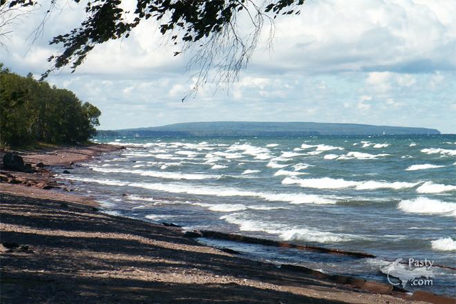
Regarding the picture of the wave action on the big lake, it was taken from the shore of Sedar Bay (now named Cedar Bay), north of the Tamarack Waterworks a few miles. N47 18.821 W88 28.630, to be exact.
The lighthouse at the north entry can be seen as a small white triangle.

The beach when we arrived in June was wider than we have ever seen it, since 1988 when we took up summer residence on Sedar Bay. What you see on the waters edge in the picture are sandstone slabs that uplifted when the peninsula was formed. In June these slabs were covered by sand and pebbles, but heavy wave action removed the sand leaving the slabs. The slabs vary in height from 6 to 10 inches, and slope down way out into the lake. Some years back, the entire beach was sandstone slabs at some of our neighbors south of us.

Thank you for your comments. My wife and I found the Keweenaw in 1949, while on our honeymoon. In the late fifties we started coming up here from Indiana to hunt for copper and other minerals on the abandoned mine dumps and lake shores of the Keweenaw. Now we sit and watch the ore ships go by and enjoy the wonders of the big lake.


By
Deb S. (Usedtobeayooper) on Saturday, September 1, 2007 - 03:52 pm:

Thanks Bob! That was all so interesting. Everybody's been wondering about it all. You are a lucky man indeed.


By Dean Beaudoin (Deanb) on Friday, September 7, 2007 - 08:25 am:

I just stumbled accross this photo today 9/7/07. I immediately recognized it as being taken from Sedar Bay. It looks to be from around the old Abramson place or thereabouts. My mom has a place just around the first point in the picture. I spent every summer as a kid either walking that beach or running around in a tiny sailboat with an Evinrude on it that belonged to Armour Sarkela. My cousins from the Rowe family and I used to run all over that area as kids between Armours place all the way north to 7-mile point.


Powered by:  
Join Today!
Each day the Pasty Cam has 2 areas to post messages: 
  • Cam Notes - comments related to today's picture and discussion
  • What'sUP - other topics, conversation and announcements
  • *** Please use the appropriate forum ***
    Here's a list of messages posted in the past 24 hours
    See our guest photo gallery for more great views from the U.P.

    Add a Message


    A user/password combination is now required to post messages to Cam Notes. Registration is free. Click here to register or maintain your I.D.
    Username:  
    Password:

    Home | Pasty Cam | Contest | Order Now | Bridge Cam | Past-E-Mail | GP Hall of Fame | Making Pasties | Questions