Aug 20-07

Past-E-Mail: Cam Notes - 2007: August: Aug 20-07
Looking back at the Keweenaw    ...scroll down to share comments
Photos by Lynn Virtanen
Almost there    ...scroll down to share comments
Photos by Lynn Virtanen
Storage building    ...scroll down to share comments
Photos by Lynn Virtanen


By
Mary Drew at Pasty Central (Mdrew) on Monday, August 20, 2007 - 04:14 am:

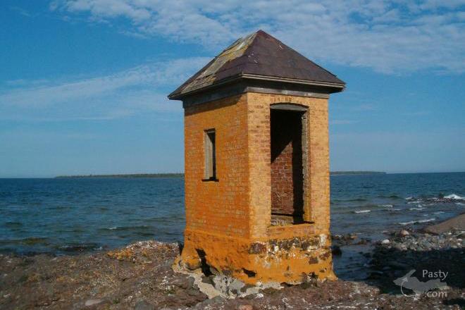
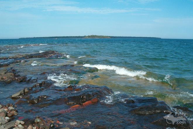
Where in the Keweenaw was Lynn Virtanen standing when she snapped the first photo? It's a view of the Keweenaw not often seen from this vantage point and Lynn's other two photos tell the "rest of the story". That's Gull Rock lighthouse on the tip of Manitou Island, which can be seen from one the further-most points of the Keweenaw Peninsula, High Rock Bay. We've seen the view from the tip out towards Manitou before, but looking from Gull Rock back towards the mainland is a bit more rare. I don't know about the rest of you, but I'm quite impressed with Lynn's mode of transportation out to the lighthouse, by kayak! I'm just estimating, but I think the waterway between the end of the peninsula and the island is about a two-mile paddle and for the most part in wide open Lake Superior waters. Anyone who boats on this Big Lake knows how quickly she can stir up into a frenzy, thus my reason for admiration of her bravery. The third photo is some sort of storage building near the lighthouse on Gull Rock. My guess is this may be where the lighthouse keeper stored the oil for the light, back when it was in operation


By Michael Du Long (Mikie) on Monday, August 20, 2007 - 04:47 am:

Mary it looks more like a brick out house, wanted to use the other word but was afraid of being cut off.


By Theresa R Brunk (Trb0013) on Monday, August 20, 2007 - 05:07 am:

What year was the lighthouse establish? I have never been out to this one. Kudo's to Lynn for getting out there by kayak. Was she alone or did she have company?


By Lowell La Fave (Lowell) on Monday, August 20, 2007 - 05:29 am:

Good Morning
These are great pictures. I would think I would need a bit bigger boat if I was to go out there.
Have to admire her for doing that.
That is quite a paddle but then the native people of Northern Alaska and Canada go out on the Ocean with theirs hunting Seals etc.
Would have to agree with Mikie it looks more like the NECESSARY as some people call it.


By john mich (Johnofmi) on Monday, August 20, 2007 - 06:33 am:

There is a lot of info on the internet about the Gull Rock Lighthouse. Here are a few links:

http://www.gullrocklightkeepers.org/gullrock.htm

http://www.nps.gov/history/maritime/light/gullrock.htm

http://www.terrypepper.com/lights/superior/gull-rock/

And, Yes, that is not a storage building. From the above links:

Other Structures: BRICK PRIVY

\image


By Theresa R Brunk (Trb0013) on Monday, August 20, 2007 - 06:40 am:

Wow! Thanks for the links John. Being a Plumber I am always interested in the "History" of Privys'. And the other stuff including the link to the Coast Guard Cutter Mesquite was also very interesting.


By Deb S. (Usedtobeayooper) on Monday, August 20, 2007 - 06:55 am:

WOW! That is one brave woman. I could never do what she did. Hats off to her and to the great pictures.


By Cindy, New Baltimore, MI (Cindy) on Monday, August 20, 2007 - 07:11 am:

These are amazing pictures. I have only seen Gull Rock from a distance a few years ago on a sunset cruise. I'm amazed at how Lynn made it to this light by kayak. From what I understand, the water is very deep and treacherous around the island. I'm also wondering how she got to the tip of the Keweenaw. I didn't think there were any passable roads that took you there. Did she kayak around the point? Great pictures, Lynn!


By Brooke (Lovethekeweenaw) on Monday, August 20, 2007 - 07:52 am:

She has guts, and it got some good pictures.


By Marianne Y (Marianne) on Monday, August 20, 2007 - 08:06 am:

Those are awesome pictures, but I'm with Lowell, I would definitely need a MUCH bigger boat to go out into the open waters of Mother Superior. Kayaking in the Portage or Torch Lake or something is one thing. But kayaking in the open waters of Mother Superior, well...

Lowell mentioned that Native people in northern Alaska and Canada sometimes use this mode of transportation. If my memory serves well, so did Father Marquette and some of the other famous men in the history of the UP, because that is all they had. :-)


By Janie T. (Bobbysgirl) on Monday, August 20, 2007 - 08:13 am:

Lynn's pictures and journey by kayak are backed by "no guts, no glory"! What an exciting day it must have been for her!


By Keith in Kansas (Keithinks) on Monday, August 20, 2007 - 08:14 am:

Nice shots! It's possible to drive out to High Rock Bay, but you definitely want to do it with 4 wheel drive (especially the last half mile or so). I have a few shots from one of my treks out there in one of my albums. http://gallery.pasty.com/keithinks/albup85/scan0014.jpg.html


By Michael Du Long (Mikie) on Monday, August 20, 2007 - 08:15 am:

I had a girl friend who was built like that brick Privy, still hard not to use the other name for it.


By FJL (Langoman) on Monday, August 20, 2007 - 09:06 am:

Mikie, would that be "Precious"???


By Cindy, New Baltimore, MI (Cindy) on Monday, August 20, 2007 - 09:17 am:

Keith, I wish I had known this when we were up there a little over a week ago. We would have put our 4 wheel drive to good use, too. Those pics look great in your album. Do you take the road past Fort Wilkins in Copper Harbor? We drove for a while on that road and didn't know where it was taking us.


By Capt. Paul (Eclogite) on Monday, August 20, 2007 - 09:33 am:

I think what Mikie is trying to say is that it looks like a brick coprolite house!!! ;-)

What impresses me is that the building is still there and hasn't been sent to the depths by ice jams in the winter. It looks like that building is well cemented in place though. I have been out to Manitou a few times; not during this last trip however. Lots of neat rocks out there to hunt for....


By Uncle Chuck @ Little Betsy (Unclechuck) on Monday, August 20, 2007 - 09:34 am:

That boat ride to the island is spooky in a 21 foot boat, I've been out there many times in some serious waves.

Cindy, yes, follow the road out of Copper Harbor approx. 5 miles,the High Rock Bay road is on your left and I think its even marked now. We've been out there many times, it's a great 4x4 ride, and what a view at the end.


By Janie T. (Bobbysgirl) on Monday, August 20, 2007 - 09:37 am:

Keith..your link has some great pics! My husband and I ventured out that way on our snowmobiles several times.


By Donald Kilpela (Commodore) on Monday, August 20, 2007 - 10:06 am:

I doubt that's a privy; it's too permanent and any privy builder or owner will tell you that it has to be relocated from time to time. As Mary wrote, it was probably used for some sort of storage or equipment.


By k j (Kathiscc) on Monday, August 20, 2007 - 10:44 am:

As John Mich said-it is a brick privy-\image {gullrock04-s}


By k j (Kathiscc) on Monday, August 20, 2007 - 10:46 am:

ok, did that wrong will try again gullrock04-s


By JohnS (Jksturos) on Monday, August 20, 2007 - 10:48 am:

I happened to be out at the Gull Rock Lighthouse this past Saturday, with my friend Ryan. What a beautiful spot. We used a more convenient method of travel than a kayak - two-person jetski. We saw two kayakers paddling by on our way out there from the Mouth of the Montreal River - maybe one of them was Lynn V. We both agreed we'd rather be kayaking than jetskiing - maybe next time.
Theresa, the date on the lighthouse read 1867. That's 140 years ago!!


By Dunerat (Dunerat) on Monday, August 20, 2007 - 10:55 am:

That little structure may very well have been used to store the oil used to illuminate the light before the days of electricity. Oil was often stored away from the main structures to reduce fire risk.


By JohnS (Jksturos) on Monday, August 20, 2007 - 11:07 am:

Ryan and I both thought it was a brick outhouse when we were there on Saturday (8/18).
We were disappointed that we didn't have a camera.


By Brooke (Lovethekeweenaw) on Monday, August 20, 2007 - 11:22 am:

Has anyone else noticed the proximity of this privy to the lake? Is this the real reason why they want us to limit our intake of great lakes fish? Just food for thought.


By Richard A. Fields (Cherokeeyooper) on Monday, August 20, 2007 - 11:26 am:

I can't give the definitive privy or not answer, but here is the information from the National Register listing.

Gull Rock Light Station
Gull Rock, .5 mile west of Manitou Island, 11 miles ESE of Copper Harbor, Copper Harbor vicinity - Keweenaw County Property Type lighthouse

Historic Use DEFENSE/coast guard facility
TRANSPORTATION

Current Use TRANSPORTATION

Style Other

Narrative Description The Gull Rock Light consists of an attached keeper's dwelling and light tower. The tower is a square brick structure with exterior dimensions of nine feet with an inner wall supporting the interior staircase. The tower measures forty-six feet in height to the top of the ventilator ball. The iron lantern is ten-sided with vertical bars. The keeper's dwelling is two stories in height and has a gable roof. It has suffered severe interior deterioration because it has been unoccupied and open to the ravages of the weather.

Statement of Significance Gull Rock was a serious threat to ships attempting to pass between the tip of the Keweenaw Peninsula and Manitou Island in the course of going from the western end of Lake Superior to Keweenaw Bay. Congress appropriated $15,000 in 1866 for the construction of a lighthouse on Gull Rock and work was carried out the following year. The light was first put into service on 1 November 1867 and exhibited a Fourth Order Fresnel lens manufactured by Barbier and Fenestre of Paris. This lens has been replaced with a two hundred and fifty millimeter plastic lens which continues to operate.
Period of Significance 1866-1900

Significant Date(s) 1867

Registry Type(s) 07/19/1984 National Register listed

Site ID# P23788


By Yahoo in Flatland (Yahooinflatland) on Monday, August 20, 2007 - 12:12 pm:

In 1992 or 1993, 3 of us drove a Jeep out to high Rock Point, and camped overnight out there.
No tent, just sleeping bags and a warm fire. The best camping spot I have ever had! Awesome views.
We had to traverse the creek shown in Keith's photos... http://gallery.pasty.com/keithinks/albup85/scan0014.jpg.html
The next morning, it started to rain, HARD and FAST!
We packed up that camp in record time and we were loaded in our Jeep in 5 minutes after it started pouring...
By the time we made it to the creek, it was a river!
We just barely made it thru!
One of my favorite memories of the Keweenaw!


By Bob Gilreath (Bobg) on Monday, August 20, 2007 - 01:42 pm:

We were at High rock in the early 80's when a storm hit also. we started leaving, got part way and a tree was down on the road, My buddy and I got out to move it just as lightning struck close by.

We didn't get hit, but both of us were temporarily blinded by the flash. My wife siting behind us in the truck thought we were gonners.

That's as close as I wanna be to a strike. ;-)

We moved the tree and got out of there asap.


By Danielle Adams (Badkid) on Monday, August 20, 2007 - 03:55 pm:

Cindy,
it is possible to get out there. The Keweenaw Rocket Launch site is also out there. Here are directions..... To get to the site drive north on US 41 up to Copper Harbor. In Copper Harbor, turn right at the blinking traffic signal and proceed about 5 miles to the end of US 41. There is a seasonal road (not plowed in winter seasons) that begins here, take it about 4.5 miles, turn left onto the trail marked for High Rock Bay. This trail is impossible to pass by car and is best done by foot, mountain bike, or ATV. Down the trail there is a fork, take it to the left, shortly after you will find the site.
I have been out there, it is awesome but all that is left to the site is a cement pad and some iron rails. This is a great place to sit and watch the freighters go by.

Earlier this year there was a picture of the American Valor as the picture of the day up off the Keweenaw. That boat is formerly the Armco of the Oglebay Norton Co. fleet. The American Steamship Co. bought the Norton fleet for $120 millon in June of 2006.


By Kathy P. (Katiaire) on Monday, August 20, 2007 - 04:00 pm:

Nice photos, Keith. Such a beautiful solitary place. Thanks for sharing.


By Cindy, New Baltimore, MI (Cindy) on Monday, August 20, 2007 - 06:02 pm:

Thanks, Danielle and Uncle Chuck for the directions. I am printing this and putting it in my folder for my next trip to Copper Harbor. We drove on that road for a short time but it was already starting to get dark, so we turned around. If we had known where it was going, we could have taken the trip the next day. Oh well, next year. Thanks.


By Uncle Chuck @ Little Betsy (Unclechuck) on Monday, August 20, 2007 - 06:18 pm:

Yahoo and Bob G. Great stories, glad you were'nt fried Bob! Like reading those 4x4 tales!


By Margaret, Amarillo TX (Margaret) on Monday, August 20, 2007 - 08:54 pm:

I love 'em all.


By Shirley Milford (Grannymim) on Monday, August 20, 2007 - 10:25 pm:

One of my favorite Pasty.com pictures is E Neil Harri's aerial photo of Gull Rock Lighthouse on July 10. 2006.

https://www.pasty.com/discus/messages/1853/2358.html


By Jeremy (Jst) on Tuesday, August 21, 2007 - 01:09 pm:

Following the directions given by Danielle, I seen this: mystery, does anyone know what it is?

Mary says: I'm not positive, but my guess is that it is the location of a large tower that can be seen from Schlatter's lake, looking back towards Copper Harbor. I have no idea if the tower is for radio or what, but that would be my guess...anyone?


By David Clark (Dcclark) on Thursday, August 23, 2007 - 10:34 am:

Yes, that weird three-pronged thing is a radio/communications tower of some kind. There is another one located just east of the Garden City Road (check maps.live.com to see). You can see from the road that it's some sort of tower. My plat book shows a small chunk owned by "State of MI Police" in both locations.


By Jeremy (Jst) on Thursday, August 23, 2007 - 12:13 pm:

Mary, David
Thanks for the responses. I have looked at aerial photos of that area before (Copper Falls area also) and never notice it. Maybe recently they brushed the area around the guy wires?


By FRNash/PHX, AZ (Frnash) on Thursday, August 23, 2007 - 01:04 pm:

David Clark (Dcclark):
"There is another one located just east of the Garden City Road (check maps.live.com to see)."


Sure 'nuff, there is! Click here to see the map.
Here's a closeup view:

Tower near Garden City Rd

Both towers are new to me!
(I'm beginning to think I've been away from the ol' Copper Country far too long!)


By Mary Drew at Pasty Central (Mdrew) on Thursday, August 23, 2007 - 04:10 pm:

Here's the photo "FRNash" was trying to post...

Tower near Garden City Road

By
D. Clark (Dcclark) on Thursday, August 23, 2007 - 04:24 pm:

Incidentally, maps.live.com (and google maps too?) seem to label the north-south(ish) road here "Brockway Mountain Drive", whereas I've always called it the Eagle Harbor Road. Plus, Copper Falls is shown at the little Y-intersection at the bottom. They never seem to get the area right!


By FRNash/PHX, AZ (Frnash) on Thursday, August 23, 2007 - 05:25 pm:

D. Clark (Dcclark):
"… [various mapping programs] seem to label the north-south(ish) road here "Brockway Mountain Drive … I've always called it the Eagle Harbor Road."


I've known that stretch of road as "Eagle Harbor cutoff Road" but Brockway? Never!

"They never seem to get the area right!"
Boy, that's for sure, even after the massive "911" renumbering exercise, the map makers still rarely have the new addresses right. How many years now since that exercise?

(Thanks Mary, for fixin' the failed upload!)


By Dr. Yooper (Dryooper) on Sunday, August 26, 2007 - 11:42 am:

Jeremy (Jst), the structure in your image is indeed a radio tower owned by the State of Michigan. It is tower WQBA646, part of the Michigan Public Safety Communications (MPSCS) System. Both the State Police (state wide) use the MPSCS, as well as DNR, many local police, fire, and EMS agencies.

FRNash/PHX, AZ (Frnash), your image is also an MPSCS tower. This one is WPUY707.

And for the sake of completion, there are a few more MPSCS towers in the Copper Country. WPUY708 is near Gratiot Lake off the Gratiot Lake road, WPUY705 is in Centennial Heights, and WPUY703 is just outside of Dodgeville.


By FRNash/PHX, AZ (Frnash) on Sunday, August 26, 2007 - 01:04 pm:

Dr. Yooper (Dryooper):

Wow, thanks for the 'completion', now I'm going to have to hunt them down as well.

So many radio towers in such a small area? And given that, how many hundred more such towers statewide?

(Hmmm, izzat why they're squeezing the MSP budget, 'cuz they spent all their money on radio towers, and a new headquarters building?)


By Dr. Yooper (Dryooper) on Monday, August 27, 2007 - 09:04 pm:

There are at least 186 MPSCS towers across the state. Anyone who uses the system for communications must subscribe to the service for a monthly fee. This is where the majority of the funding comes from. The idea for this system was first proposed in 1984, and legislation was passed in 1994 that provided the initial funding. It took many years to build, and the system didn't reach the UP until 2002.

It is set up such that all the towers can communicate with one another, and so a user in, say, Copper Harbor can literally talk to another radio in, say, Lansing.

I'm not sure how much the radio system is affecting the budget, but I agree that the new multi-million dollar headquarters doesn't seem like it is coming at a good time.

For (a lot) more information, visit: http://www.michigan.gov/mpscs

Powered by:  
Join Today!
Each day the Pasty Cam has 2 areas to post messages: 
  • Cam Notes - comments related to today's picture and discussion
  • What'sUP - other topics, conversation and announcements
  • *** Please use the appropriate forum ***
    Here's a list of messages posted in the past 24 hours
    See our guest photo gallery for more great views from the U.P.

    Add a Message


    A user/password combination is now required to post messages to Cam Notes. Registration is free. Click here to register or maintain your I.D.
    Username:  
    Password:

    Home | Pasty Cam | Contest | Order Now | Bridge Cam | Past-E-Mail | GP Hall of Fame | Making Pasties | Questions