July 30-07

Past-E-Mail: Cam Notes - 2007: July: July 30-07
Sculptured rocks    ...scroll down to share comments
Photos by David Woon
More rocks    ...scroll down to share comments
Photos by David Woon
Passing freighter    ...scroll down to share comments
Photos by David Woon


By
Mary Drew at Pasty Central (Mdrew) on Monday, July 30, 2007 - 04:43 am:

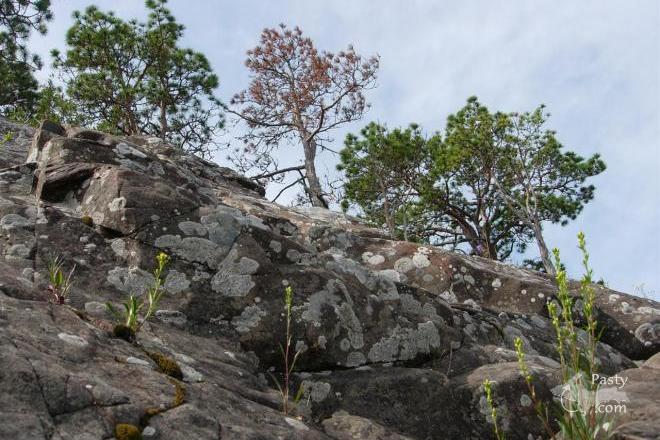
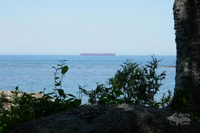
These rock formations are located on the finger of land called Hunter's Point, which extends out into Lake Superior, acting like a natural barrier as it surrounds the Copper Harbor Marina. To get there on foot, you park in the marina parking and follow the hiking trail out to the point, with a number of side trails that take you out to the Lake at various spots along the way. All three shots today, from David Woon are taken out on Hunter's Point, which is a Township park now. It's a wonderful spot for finding rocks of all shapes and sizes, checking out the flora and passing birds and hopefully spotting a freighter passing by out in the Big Lake. David's photos depict quite well this little peninsula of land, where the geological basalt formations are some of the oldest rock on earth, part of the earth's crust.


By Smfwixom (Trollperson) on Monday, July 30, 2007 - 05:47 am:

Thanks for the great pictures!


By Charlotte, Mishawaka, IN (Charlotte61) on Monday, July 30, 2007 - 07:50 am:

Good morning from Mishawaka,IN.
This is one place I plan to see next trip I make to Copper Harbor. The first trip was great but not enough time to see everything on my list. Going to get hot here--near 90 today and in the 90's for most of the week.


By Brooke (Lovethekeweenaw) on Monday, July 30, 2007 - 08:06 am:

I have never been to that park, have only been to the marina to pick up my Dad and Uncle on their way back from Isle Royal.


By Interested visitor (Tangobravo) on Monday, July 30, 2007 - 08:08 am:

To the good Doctors,

Here we have what looks like a basaltic intrusion and a pudding-stone conglomerate.

Can you describe these rocks in more detail for us?

Thanks


By Marsha, Genesee/Aura (Marsha) on Monday, July 30, 2007 - 08:46 am:

And this is why you should take your binoculars into the Harbor Haus! I always survey the Island, the lighthouse, Sharon's house, etc. while waiting for my dinner!


By Janie T. (Bobbysgirl) on Monday, July 30, 2007 - 09:19 am:

Wonderul pictures today! The freighter is my favorite! Wish I was there!


By Interested visitor (Tangobravo) on Monday, July 30, 2007 - 09:22 am:

I am not trying to put the good Doctors out of a job, but this should be required reading before traveling to the Keweenaw.

http://www.minsocam.org/MSA/collectors_corner/vft/mi1.htm


By John W (Jwahtola) on Monday, July 30, 2007 - 09:26 am:

That looks like the same freighter I took pictures of last week on Wednesday. It was faze that day also. We stopped to take the picture an the people that were on the beach did not even know it was out there until then. They were greatful we stopped so they also could see the freighter. They were from Grand Rapids Michigan. It was 88 that day hot and muggy.


By Deb (Dks) on Monday, July 30, 2007 - 10:17 am:

Thank you, Interested visitor, for the great link. My family was visting the area earlier this month, and I have been looking for something like this. I grew up in the Keweenaw, but did not appreciate what was around me at the time. Thanks!


By Ryan James Byykkonen (Rbyykkonen) on Monday, July 30, 2007 - 10:37 am:

The water level of the big lake is so low right now that you can actually walk from Hunters Point to Porters Island.


By Capt. Paul (Eclogite) on Monday, July 30, 2007 - 10:50 am:

where the geological basalt formations are some of the oldest rock on earth.
True, they are some of the oldest, but not even close to the oldest in the UP, let alone on Earth; more about that later.

What you are looking at in the first photo (and second photo for that matter) is a series of rock called the Lake Shore Traps, which is part of the Copper Harbour Conglomerate. The conglomerate overlays and interfingers the Portage Lake Volcanics, which indicates a few quiet periods between eruptions possibly signaling the end of volcanism and a change to more sediments being deposited. The Traps consist of a more massive (lacking minerals) type of basalt that is iron rich. Evidence of this can be seen in the first photo by observing the red banding in the basalt. To date, over 30 flows have been seen which are located near the top of the conglomerate. The thickness of the entire conglomerate including the Traps varies between 300 and 5400 feet. The first photo shows a typical Lake Shore Trap flow. The second photo was probably taken away from the lake by the amount of moss growing on it. There are no pudding stone conglomerates in these photos.

The age of the conglomerate and Traps is around 1087 Ma (million years), which makes sense with the older Portage Lake Volcanics underneath at 1095 Ma. These are indeed old rocks, but this pales in comparison to rocks around the Marquette area which have been dated between 1800 and 2700 Ma, and even these aren’t the oldest rocks in the UP. Near Watersmeet is an outcrop of rock which geologists have "surprisingly" called the Watersmeet Dome. These rocks, consisting of tonalitic gneiss and migmatite, have been dated to 3600 Ma. So far, the oldest rock on Earth that has been discovered is the Acasta Gneiss near Great Slave Lake in the Northwest Territories. These rocks have a radiometric date as old as 4030 Ma with some individual zircon crystals as old as 4200 Ma.

The link that was provided above is a great beginner’s guide to the geology of the Keweenaw. It gives the casual reader/visitor a good understanding of what they are looking at around them as well as an introduction to the how why and when the geologic events occurred in the region. The Dr. and I would be up there right now studying Keweenaw geology had it not been for my car getting dinged up. But, we are still coming up, just a week later than planned. I have so many requests to take people out I’m going to have to make folks take a number!!! ;-)


By Margaret, Amarillo TX (Margaret) on Monday, July 30, 2007 - 10:56 am:

Thanks Capt. Paul. didn't want that old car accident putting you out of commission. Hope you're feeling better and you'll be up for a regular look at the old penninsula.


By Deb (Dks) on Monday, July 30, 2007 - 11:21 am:

Capt. Paul, sorry to hear about your delayed trip north. Are there any other books you would recommend on the geology of the Keweenaw?


By B. McKamey (Bmckamey) on Monday, July 30, 2007 - 11:41 am:

Hunter's Point Park is a gem. As I'm sure many of you already know, an anonymous donor and the owner of property adjacent to the park recently pledged significant donations to help expand the park (Hunter's Pt. Phase II). Grant Township is raising additional funds to help complete the purchase. Here is a link to the Hunter's Point website if you want additional information or to make a donation to help preserve this resource for future generations--

http://www.hunters-point.org/


By Interested visitor (Tangobravo) on Monday, July 30, 2007 - 11:59 am:

Captain Paul,

Thanks for the detailed explanation. How small do the included rocks have to be to be called puddingstone?

One more link if you are going to be in the Keweenaw
in early August.

http://www.ccrmc.info/


By Happy to be in the U.P. (Lahelo) on Monday, July 30, 2007 - 12:00 pm:

Interested visitor (Tangobravo)
There is no need to go the doctors before you go! !Just go, no one would be putting them out of business!! LOL
Its a virtual great experience!


By Capt. Paul (Eclogite) on Monday, July 30, 2007 - 12:51 pm:

Thanks Margaret. I was a little stiff for a couple days, but I'm feeling wonderful now and ready to do some serious hiking on the Peninsula next week. A mere car accident won't stop this Scotsman!! ;-)

As far as a good book, one of the best is the "Self guided geologic road trip of the Keweenaw Peninsula" that Dr's Bornhorst and Rose put out a number of years ago through the ILSG. You can find this book at most of the gift shops around Houghton and at the Seaman Mineral Museum. Another good book, although a bit harder to read for the novice, is close friend Dr. Gene Leberge's "Geology of the Lake Superior Region". This book covers the entire Lake Superior region and really ties everything together concerning the MidContinent Rift.

Puddingstones are actually quartz conglomerate that contains nice rounded pieces of jasper (the red rock) scattered throughout. They are most commonly found on the far eastern end of the UP and the northeast corner of the LP. They were formed in an ancient river channel located in eastern Ontario, then scraped up by the glaciers and carried down to Lake Huron. One of the actual source localities was recently discovered around the hills of Bruce Mines, Ontario where an entire ledge is composed of puddingstone.

It's funny Tango that you posted a link to the local rock club and rockhound activities next week. In 2003, I was the chairperson of Keweenaw Week and was the brainchild in bringing the cast skull of "Sue" to the Keweenaw from the Field Museum in Chicago for the gem and mineral show that year.


By Deb (Dks) on Monday, July 30, 2007 - 02:01 pm:

Thanks for the book info, Capt. Paul. I enjoy reading your posts.


By Capt. Paul (Eclogite) on Monday, July 30, 2007 - 02:52 pm:

I guess I should have included in my earlier post about the size of the clasts in the stone. I'm not aware of any size requirements of the jasper clasts to make it a puddingstone; I have seen very small and relatively large pieces of jasper and other rocks in puddingstone. I am told that in some stones gold, sapphire, chromite, and titanite have been found, which wouldn't surprise me given its origins in streams and rivers.

As you probably have already figured out, I love talking geology, especially in the Lake Superior region, the most geologically fascinating area in the world.....


By Douginwi (Douginwi) on Monday, July 30, 2007 - 03:41 pm:

We hiked part of the Hunter's Point trail last Thursday. It is beautiful. However, I have a disabled daughter that had some trouble with the exposed roots and rocks. We could not make it to the end but we certainly enjoyed the part we saw.


By Bob Gilreath (Bobg) on Monday, July 30, 2007 - 04:10 pm:

Ok I've been meaning to do this for a couple weeks now

Here's my little Stump the geologist Quiz.

Although I think The good Dr will ID this place easily.

Where did we go on vacation, and no you cant go thru my albums and find it cause these are the only ones posted yet! ;-)

Who can be the first to tell where we went on vac?

http://gallery.pasty.com/bobg252/geo_quiz/


By Matt Schnippert (Schnippert) on Monday, July 30, 2007 - 04:47 pm:

You're at Hopewell Rocks in the Bay of Fundy in New Brunswick. My wife and I spent our honeymoon in the maritime provinces.


By Capt. Paul (Eclogite) on Monday, July 30, 2007 - 05:14 pm:

Well, I would have been the first if I hadn't been on my nasty commute through Houston traffic, and the good Dr. doesn't read the PastyCam except at work, hehe....

Yup, that's Hopewell Rocks on the Bay of Fundy. They are formed from iron-rich deposits being shed off the Caledonia Mountains and cemented together over millions of years. Funny thing is, the Caledonia Mountains are located in present day Scotland and Norway, not in New Brunswick!! This would indicate that North America and Europe were indeed connected at one time, long before the opening of the Atlantic Ocean basin.


By Tim Holland (Tholland) on Monday, July 30, 2007 - 08:08 pm:

I remember standing on some big rocks on Hunter's Point a few Novembers ago with a few friends while a powerful storm was kicking up 10 foot waves. One sneaker wave came up and washed us off of the rock. We learned our lesson that day about playing chicken with Lake Superior. We were lucky the worst thing that happened is getting soaked head to toe with 40 degree water.


By Bob Gilreath (Bobg) on Tuesday, July 31, 2007 - 08:16 am:

That was too easy, now I'm gonna be on a quest to stump the Capt. ;-)


By Danielle Adams (Badkid) on Tuesday, July 31, 2007 - 11:28 am:

where is hunters point? gee nobody took pictures of the passing tug & barge that came through saturday afternoon?


By Mooselover (Mooselover) on Wednesday, August 1, 2007 - 03:05 pm:

Bobg,

Were you at Hopewell when the tide came in? I've heard it is absolutely fantastic. How do they warn folks to get out before it comes in?

Another question to all of you who post so early in the morning....do you get up early or are you staying up late?


By FRNash/PHX, AZ (Frnash) on Wednesday, August 1, 2007 - 03:20 pm:

Mooselover (Mooselover):
"…to all of you who post so early in the morning....do you get up early or are you staying up late?"


For some of us it's a combination of staying up late three time zones west of da Yoop (MST in AZ, PDT in CA); the extra three hours helps quite a lot.


Powered by:  
Join Today!
Each day the Pasty Cam has 2 areas to post messages: 
  • Cam Notes - comments related to today's picture and discussion
  • What'sUP - other topics, conversation and announcements
  • *** Please use the appropriate forum ***
    Here's a list of messages posted in the past 24 hours
    See our guest photo gallery for more great views from the U.P.

    Add a Message


    A user/password combination is now required to post messages to Cam Notes. Registration is free. Click here to register or maintain your I.D.
    Username:  
    Password:

    Home | Pasty Cam | Contest | Order Now | Bridge Cam | Past-E-Mail | GP Hall of Fame | Making Pasties | Questions