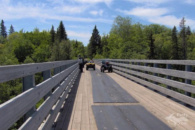
This is a familiar sight if you've done any four-wheeling (or snowmobiling) in Ontonagon County. It's the Firesteel Bridge, where Jamie Harter was recently out enjoying the back country trails. Today's third shot puts you atop the bridge, looking down, where you spy the Firesteel River as it makes its way through the forested land. From what I understand there are three bridges in a short distance and they were all, at one point, used for the railroad. Converting the bridges from rail to trail could be considered U.P. recycling at its best!
By Dean Woodbeck (Dwoodbeck) on Tuesday, August 8, 2006 - 06:49 am:
The Still Waters silent auction continues through Friday -- just a few more days to support the assisted living home. If you are in town Sunday, stop by for the open house and the end of the auction, 12:30-3:30 pm on August 13.
By paul (Pungvait) on Tuesday, August 8, 2006 - 06:50 am:
good morning - 51 degrees in beautiful downtown Mason (Osceola twp.)
By Deb S. (Usedtobeayooper) on Tuesday, August 8, 2006 - 07:30 am:
Never been there. Looks like fun!
By JanieT (Bobbysgirl) on Tuesday, August 8, 2006 - 07:38 am:
Been there, done that, on our snowmobiles. Great time!
By Danbury (Danbury) on Tuesday, August 8, 2006 - 09:30 am:
What railroad was that? Can't find any on my map for that particular area (Firesteel River). There's something about old railroads that intrigues me, so I'm curious.
By Kevin E. Musser (Copperrange) on Tuesday, August 8, 2006 - 09:57 am:
The Copper Range Railroad built the three Firesteel River Bridges in 1899 and used them until 1972. They are located just north of Lake Mine in Ontonagon County.
By Ms. Katie (Mskatie) on Tuesday, August 8, 2006 - 10:03 am:
Just curious, why does the water look brown? It looks like there is Ga clay in it:) I don't think I have ever seen this bridge.
By Jeff Kalember (Jeffkal) on Tuesday, August 8, 2006 - 01:00 pm:
many western UP rivers look like this. The Ontonagon in particular. Lots of clay and high iron content.
By Happy to be in the U.P. (Lahelo) on Tuesday, August 8, 2006 - 01:54 pm:
Been on that bridge many a times, its always fun to cross and see how far down the river really is. Fun for anyone any age!! You can take a regular car on this part of the trail and over the bridge. I have done it plenty of times with no problems..........its really a sight to see.
By Margaret, Amarillo TX (Margaret) on Tuesday, August 8, 2006 - 03:13 pm:
Fran in GA. I haven't been to this particular area, but Taquamenon Falls is that color because of the Tannin. Maybe Dr. Paul can help.
By Uncle Chuck @ Little Betsy (Unclechuck) on Tuesday, August 8, 2006 - 03:18 pm:
Look's very similar to the tressel in Marquette that we use to hike to while at NMU, but I think the one in Marquette is still an active train track.
By Steve De Cloedt (Steveinsouthben) on Tuesday, August 8, 2006 - 03:43 pm:
I don't think the water is brown. if you look between the two shadows you can see a log on the bottom of the stream. I think the water is clear.
By Danbury (Danbury) on Tuesday, August 8, 2006 - 04:16 pm:
The one in Marqueete is still active. A great hike though. Still has the little "oops I'vee been caught in the middle of the brige and the train is coming" safety platforms on it.
By FRNash/PHX, AZ (Frnash) on Tuesday, August 8, 2006 - 05:46 pm:
Steve De Cloedt (Steveinsouthben): "I don't think the water is brown. ... I think the water is clear."
No, really, what you see is the true color of the very brown water. Jeff Kalember (Jeffkal) nailed it exactly. It's due to lots of clay and high iron content. Lots 'o nasty, very sticky red clay!
By Lorelei (Lorelei) on Tuesday, August 8, 2006 - 06:19 pm:
I close my eyes whenever I ride in a car over these bridges. Never in a million years would I drive over them. Scary.
By Dr. Nat (Drnat) on Tuesday, August 8, 2006 - 07:01 pm:
It's not so much dissolved iron as Ontonagon clay, a nice, red clay. Several rivers including the Ontonagon River are this reddish colour because of the clay. Margaret, the Taquamenon River and other rivers in that area are rootbeer coloured due to tannins from the tamarack trees.
By Fran in GA (Francesinga) on Tuesday, August 8, 2006 - 09:26 pm:
Well,I thought that looked like this clay here. I never knew there was red clay in the UP.:( Hate that stuff,it is an awful mess when it gets wet. Dollar Bay was rock and sandy soil.My Dad had to add a lot of compost to have good soil for his gardens. There must be a lot of different type soils in the UP.
By Deb S. (Usedtobeayooper) on Tuesday, August 8, 2006 - 10:03 pm:
Fran, There's a real nice rest stop between Bruce Crossing and Mass. If you go there you'll see the river is this color. The clay is just red. It looks as if you'd just sink in if you stepped in it. And many of the rivers UP there are like that.
By Steve Haagen (Radsrh) on Tuesday, August 8, 2006 - 11:24 pm:
Deb that nice rest stop has been closed for over a month, anybody know why?
Geez, they just redid the whole thing so why would it be closed? I didn't realize. I usually stop there every time to use the facilities but didn't this time so I didn't even notice that it was closed down. Bummer!!! What happened? Anybody?
By Danbury (Danbury) on Wednesday, August 9, 2006 - 03:09 am:
Speaking of soils, there must have been a publication not too long ago that some way or another made mention of tracks of the pioneers moving west that can still be found in some wooded places where they went through. Not as tracks, like in rocks, but as soil change, compacted soil, somewhere maybe along the Oregon Trail, I think. Captain Paul? Anybody?
By Dr. Nat (Drnat) on Wednesday, August 9, 2006 - 12:40 pm:
Fran: Several years ago I ran the soil laboratory at the New Mexico Bureau of Geology. It is amazing how variable soils can be over relatively short distances. The type of soil that develops in a place depends upon the bedrock type, the slope of the surface, vegetation present, climate, and the amount of time the soil has had to form. In fact, the U.S. Department of Agriculture classifies soils into twelve major types with thousands of subtypes.
By Mary Lou Curtin (Marylou) on Wednesday, August 9, 2006 - 12:55 pm:
Read recently that the guage of todays rail-road tracks were determined by the wheel-ruts of the chariots of the Roman Legions...the first rail-roads in Europe used this guage to build tracks because the Romans established the great cities of Europe. We followed them when we established our tracks. Wonder if this is a fact??
By Michael Du Long (Mikie) on Wednesday, August 9, 2006 - 01:11 pm:
Yes this is true about the width of the rails.It would have made sense here since there is so much room to make the rail larger, in Europe there isn't as much room as we have here.
By Capt. Paul (Eclogite) on Wednesday, August 9, 2006 - 03:19 pm:
If one is very interested in the soils of Houghton, Keweenaw, or Baraga Counties, you can go to the HKCD office in Houghton or the USDA office in Hancock and they should have a nice (sometimes boring) book of all the soils that are found in those counties.
Powered by:
Each day the Pasty Cam
has 2 areas to post messages:
Cam
Notes - comments related to today's picture and discussion
What'sUP
- other topics, conversation and announcements
***
Please use the appropriate forum *** Here's
a list of messages posted in the past 24
hours See our guest
photo gallery for more great views from the U.P.