May 17-06

Past-E-Mail: Cam Notes - 2006: May: May 17-06
Little Carp River    ...scroll down to share comments
Photos by Nate Alwine
Bridge over Little Carp    ...scroll down to share comments
Photos by Nate Alwine
Cold feet    ...scroll down to share comments
Photos by Nate Alwine


By
Mary Drew at Pasty Central (Mdrew) on Wednesday, May 17, 2006 - 07:09 am:

The latest adventure of Pasty Cammist Nate Alwine (and friends), takes us to Ontonagon and the Porcupine Mountains, on the North Country Trail. These pictures are from day three, of a four day hike through various rivers, down a number of trails, across several bridges and included a few dips in chilly waters (have to bathe somehow, right?). The first shot is the Little Carp River. The second shot is a bridge crossing the Little Carp River. The third shot is Nate and company, making their way across Little Carp River, barefoot! Now, when you put this trio of pictures together, what comes to mind? I'm wondering if these guys just needed a good foot bath after hiking for three days and that's why they didn't cross on the bridge. Or perhaps there's a troll under the bridge and he wouldn't let them cross to the other side. :->

If you'd like to take a virtual hike along the four day route with this rugged crew, click on over to this slideshow of 113 pictures taken along the way!


By Deb S. (Usedtobeayooper) on Wednesday, May 17, 2006 - 07:12 am:

Very nice! It sure looks cold though. I wouldn't go in.


By Tim in Oscoda (Timmer280) on Wednesday, May 17, 2006 - 07:43 am:

What a GREAT slideshow...it looked like an awesome adventure! Thanks to Nate for sharing it.


By kosk in Toronto (Koskintoronto) on Wednesday, May 17, 2006 - 07:45 am:

This summer for sure--the Porkies.
Somehow I don't think my fifty somethingish
cousins and I will be fording any rivers in our
bare feet, but we will enjoy the hike and vistas.
This year instead of looking back at the
Porkies from the Apostle Islands, we'll be
looking for the Apostle Islands from the
Porcupine Mountains.


By Happy to be in the U.P. (Lahelo) on Wednesday, May 17, 2006 - 07:57 am:

Nate when were you at the Porkies? In the spring just recently? Sure don't see any other leaves on anything else. I hope it wasn't too cold for you all. We were there a couple of weeks ago.....when it was really windy and cold. And boy was it windy. It is always breath taking anytime of the year. Looks like you had a great time.


By Nate (Nalwine) on Wednesday, May 17, 2006 - 08:11 am:

Hey all, boy I wish I was back there! One of the trails we followed actually crosses the Little Carp River 4 times, and only one of those times is there a bridge so we had to wade across that river each of the other times. Some of the guys would try anything to keep their feet from getting wet!

Happy--we were in the Porkies from Thursday May 4- Sunday May 7. Did you happen to be there at that time?


By Nate (Nalwine) on Wednesday, May 17, 2006 - 08:13 am:

Oh one more thing. One of the coolest thing about this trip was the Gondola. So check out the video "Gondola Trip" at the following link:

https://pasty.com/pcam/albux65?&page=8


By Smfwixom (Trollperson) on Wednesday, May 17, 2006 - 08:18 am:

Looks like fun, esp. the wading!


By Marsha, Genesee/Aura (Marsha) on Wednesday, May 17, 2006 - 08:25 am:

Thanks, Nate, for the refreshing slideshow! My dad is quickly slipping away with pancreatic cancer, and those shots were a helpful transition between home and work this morning. Can't wait to watch the slideshow again at home tonight on my own computer where the pictures will be better.


By Roger Janke (Rkjstpaul) on Wednesday, May 17, 2006 - 09:00 am:

For all you Norskies out there HAPPY SYTTENDE MAI!!!!


By Margaret, Amarillo TX (Margaret) on Wednesday, May 17, 2006 - 09:33 am:

Cool! We should take a field trip and climb a few hills. Yeah, hahahahaha!


By JoAnne, Washington State (Davejostef) on Wednesday, May 17, 2006 - 10:28 am:

Wow...what an incredible adventure those guys went on! I'm so jealous! The pictures are just magical. Do go look at the slideshow if you haven't done so. It's a few minutes well spent!


By jim lu maye (Jimlu) on Wednesday, May 17, 2006 - 11:42 am:

can some one tell me some info on the plane those guys were filming. thanks great side show & super pic.
thanks
jim


By Kathyrn Laughlin (Kathyl) on Wednesday, May 17, 2006 - 12:14 pm:

Hi
Nate, I only got a glimpse, but I think the yellow flowers you mntioned were trout lily (also known as adder's tongue & dog-tooth violet).

All the fording of streams reminded me of a book I'd read: "A Walk in the Woods" by Bill Bryson, in which the author, an overweight humorist, attempts to hike the Appalachian Trail. The part where he's in Maine he has adventures in fording. It's a very funny book, if you haven't read it.


By Nate (Nalwine) on Wednesday, May 17, 2006 - 12:38 pm:

kathyrin, thanks for the info on the flowers, I was curious about what they were. I've read that book by Bryson. And I remember the part about them fording the stream, falling down in the river I think and when they got to the other side of the stream they watched another pair of hikers walk right through the river without trying to keep their feet dry. I thought of that part of "A walk in the woods" often. :)

Jim, That plane was a B-17 Bomber that was flying from Sawyer Air Force Base to Iowa during WW II. Somewhere in the vicinity of Summit Peak one of its engines caught fire and the crew had to parachute out. It crashed into the woods and the crew spent the next 14 days trying to make their way back to Silver City in the winter time. The pilot who was the last to jump ended up getting stuck in a tree and blacking out. When he woke up he looked down and saw 3 black bear staring up at him from the base of the tree.


By Nate (Nalwine) on Wednesday, May 17, 2006 - 12:43 pm:

If anyone would like directions to the crash site I can give them to you along with GPS Coordinates. Just email me (nate.alwine@ge.com)

Just promise me you'll leave what's left of the crash site intact and take nothing and I'll forward that info on to you.

I actually spent 8 years looking for this site before I found it. I'd take trips to the porkies and spend my weekends trouncing through the woods until it got dark marking off areas where I knew it wasn't. When it'd get dark I'd make camp and keep looking the next day. I found a lot of neat things aside from the plane so they were 8 years well spent :)


By Gary W. Long (Gary_in_co) on Wednesday, May 17, 2006 - 03:47 pm:

Nate: I always thought Black Bears hibernated during the winter, no?


By Charles Pomazal (Cpomazal) on Wednesday, May 17, 2006 - 05:50 pm:

Nate, How could the B-17 have been flying from K.I. Sawyer to Iowa during WW2? Sawyer AFB wasn't in existence until 1957 (or so).


By Nate (Nalwine) on Wednesday, May 17, 2006 - 07:12 pm:

Charles, well I assumed it was KI Sawyer. I was told in the questions I asked that it was actually Marquette to Iowa, so I just tied Marquette to KI Sawyer.


By Nate (Nalwine) on Wednesday, May 17, 2006 - 07:20 pm:

Gary, the plane crashed on 4/19/1944 which means under normal circumstances during that time of year there is still a lot of snow on the ground in the vicinty so though it technically wasn't winter it was less than a month into spring and I have definately seen bears in the woods at that time. Also in the 40's and 50's there was a very large population of black bear in that area so when I was told that story about the pilot I figured it could have been a bit of a story that had grown over time, but also figured it was very likely that just that happened.


By Nate (Nalwine) on Wednesday, May 17, 2006 - 07:32 pm:

Here are a couple of sites that mention the Porcupine Mountains Crash

http://www.aerovintage.com/b17loc.htm

"http://www.mytreasurespot.com/forums/read.php?6,17298,17298"


By Nate (Nalwine) on Wednesday, May 17, 2006 - 07:41 pm:

I guess it also seems that the Plane could have crashed during a training mission out of Ontonagon (see the link I posted of mytreasurespot.com). I've heard that story before as well as the story of the plane flying from Marquette to Iowa. Not sure which one is true, but either way a big plane crashed in the woods and the crew parachuted into the woods and spent 14 days in winterlike conditions and left behind a pretty neat piece of history.


By Charlotte, Mishawaka, IN (Charlotte61) on Wednesday, May 17, 2006 - 08:13 pm:

Nate, thanks for sharing your adventure with all of us. Do you have your trip to Mishawaka planned yet?


By Rose Fields (Rosemothernatur) on Wednesday, May 17, 2006 - 09:53 pm:

Great photos, Nate! I enjoyed following along your journey and found the story about the WWII plane especially interesting!
Are the guys in your group from NMU? The one early photo looked like a part of the campus and then other photos were of nearby Presque Isle. My grandson is a junior there and his name is also Nate (Nathan).


By tom ghering (Tomgheringtcmi) on Wednesday, May 17, 2006 - 09:53 pm:

There is/was a large WW11 military base just SW of the Soo, I think it's still on some charts.


By tom ghering (Tomgheringtcmi) on Wednesday, May 17, 2006 - 10:19 pm:

The airport at Kinross was first formally designated in June 1941. The former Kincheloe Air Force Base was acquired by the US Government through lease, license, easements and by fee of different tracts and was built and established in 1941 as a refueling base for Alaska-bound aircraft throughout World War II. Construction began in 1943, and the base was first known as Kinross Auxiliary Air Field. Its purpose was to serve as a refueling stop for aircraft headed for Alaska and as a base for defense of the Locks at Sault Ste. Marie. However, no tactical units were assigned there during the war. The base was under the jurisdiction of the 4250th Army Air Force Base Unit, which was the operator of Alpena, Michigan, Army Air Force Field. This designation was from the middle of 1941 to April 24, 1945.
However there was another field west of this one. Not too long ago I read an article about it, the runways are still there, but trees have taken over.It isn't more than 15-20 miles from the Soo.


By Nate (Nalwine) on Wednesday, May 17, 2006 - 10:55 pm:

Charlotte--We're hoping to visit Mishawaka over 4th of July weekend, but aren't entirely sure yet. Hopefully soon though :)

Rose--nope none of the boys were from NMU. With the exception of Me, Jason, and Chad all of the guys were in high school. The early picture was at our church, and believe it or not, there are two Presque Isle's in the UP, so you're actually seeing pictures of the other one. I did graduate from NMU though.


By Catherine--Holland MI (Catherine) on Thursday, May 18, 2006 - 01:27 am:

I bet the helpful folks at the Ontonagon Museum can tell
you more about the bomber crash.


By paul (Pungvait) on Thursday, May 18, 2006 - 07:16 am:

the other airbase is called Raco - it's a set of mile or mile and a half runways arranged in a triangle. it shows on maps and NASA uses it for a landmark.winter time, it's used for automotive testing, last time i was ther in summer it's wide open and begging to be driven on. supposedly the concrete is six feet thick, to support large bombers being landed by new crews.


By tom ghering (Tomgheringtcmi) on Thursday, May 18, 2006 - 01:08 pm:

http://www.airfields-freeman.com/MI/Airfields_MI_N.htm Thanks paul....I found on google earth....wow, quite a sight from sattlite view.


By FRNash/PHX, AZ (Frnash) on Thursday, May 18, 2006 - 07:52 pm:

tom ghering (Tomgheringtcmi):
Thanks for the "Abandoned & Little-Known Airfields" link (I'd completely forgotten about that site).

Check the current aerial view of the Raco Airfield (now the Smithers Winter Test Center) from Windows Live Local!

In the box at the top of the page,
(above the label Where: Address, city, or other place)

Enter either
Raco, MI
or even better, the Smithers Winter Test Center address:
21105 W M-28, Brimley, MI 49715
(exactly as shown above)
then click on the little green arrow to the right.
Then click & drag, and/or use the navigation & zoom tools in the upper left corner of the map area.

You may want to get rid of the Welcome and Scratchpad items (by clicking the X in the upper right corner of each) to see more of the aerial image.


By Russ Hoenig (Russhoenig) on Friday, May 19, 2006 - 05:50 pm:

The B-17 that you hiked to is 42-30762, a very early "G" model, used for training crews prior to going overseas in WWII. We have taken 100 of pics of the crash site & identified about 2/3rds of the pieces. this message will be inseveral parts as including an excerpt from an unpublished book about this plane, the crew, & the crash. Have interviewed the 4 liviing crew members and what a tale they tell. Enjoy.
Russ


By Russ Hoenig (Russhoenig) on Friday, May 19, 2006 - 05:59 pm:

Everything seemed pretty normal at sioux city AAB(SCAAB)back in Iowa. Tom Smith's assignment was to take his cres, #3349, out for another training mission. This would be the 3rd night celestial navigation mission for Calder, our navigator. His job was to get us from SCAAB, to Marquette, MI., & back to SCAAB by plotting the stars, just like the old time mariners used to do. The goal was to be within 5 miles of SCAAB on the return.
The newspaper reports of many planes overhead werre incorrect. 42-30762 was alone over Lake Superior when an oil line to #3 engine broke, catching the engine/wing/tail on fire. Smith was instructed to head for land & bail out which they did. All were in Ontonogan the next day. The major parts of the plane were recovered by the Army as soon as the snow melted. The fate of the drew in the next message.
Russ


By Russ Hoenig (Russhoenig) on Friday, May 19, 2006 - 06:28 pm:

The fate of Tom Smith's crew goes like this. About 1 month after the crash, they flew a new b-17 from Lincoln Ne. to Bangor, Maine & to Nuts corner, Ireland. Then by train to Bassingbourn on May, 29. June 17 was their 1st combat mission. Aug. 13,1944 , their plane "Fifinella 42-107030" was hit by flak below the cockpit area & crashed in France. Smith was killed, 4 were captured, & 4 evaded capture with the help of the french underground. You have good pics of the upper gun turrent skin. Lots more info available. Porcupine Mt. St. Pk has copy of the book. Ask for Bob Sprague.
Regards
Russ


By Jeff Benya (Huron1988) on Friday, May 19, 2006 - 10:12 pm:

Russ,
I recently emailed you regarding pics of 30762 at Sioux City. I never got a reply (maybe you never got it). Drop me a line. I have some pics you may be interested in.
Jeff Benya


By Jeff Benya (Huron1988) on Friday, May 19, 2006 - 10:37 pm:

Nate,
Thanks for all your help. I owe you, big time!


By gary koistinen (Gkuprn) on Saturday, May 20, 2006 - 05:10 pm:

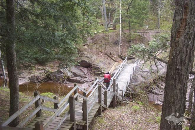
Nice to see someone out in the park using the bridge/stairway we built 20 yrs ago...i was fortunate enuff to work at/for the porkies as a "temp. ranger" for many summers, but, not fortunate enuff to be hired full time..rite place, wrong time (state was not hiring)...
regardless, it was an awesome summer for this project...myself, plus another ranger and an mcc crew had a good time...10 weeks and 300 hike miles later it was finished..most of the material was boated from union bay to the mouth of the little carp, then carrie or winched to the bridge site..engineer and layout/pour footings one day, build the next..no transits, only sitings with a 4 foot "bubble stick" and string lines..we could do this stuff in our sleep. short work days-drive to trail head, hike in, work, eat quik, work and hike bak out..
whenever i see any of the folks involved, they always tell me that it was one of the best summers ever...i still live around here and it is nice to have the porkies as "my backyard" for all seasons..and, i am possessive..so there.....
p.s. my dad bulldozed the original grade in to the crash site for the recovery of wreckage...
the crew eventually ended up at Paul's bar in silver city...a propeller, bent but intact, can be found at a local gift shop


By Nate (Nalwine) on Sunday, May 21, 2006 - 09:23 am:

Russ, I'd love to see some of your pictures. Were you saying that info was available through the Pocupine Mtn State Park?


Jeff, thank you for all your info.


Gary--The guys on the trip were asking me who built that stairway and bridge, and I said park rangers, and whoever they were they probably had a lot of fun and probably hated seeing the project end. But that me wondering just what it would be like to be on that crew. Know I know


By Russ Hoenig (Russhoenig) on Thursday, June 15, 2006 - 08:00 pm:

Have written an unpublished book about this crash. There is a copy with B. Sprague, park historian & a copy with the Ontonogan Historical Society/Museum, but their copy does not contain hiking instructions at the parks request.
Regards
Russ


Powered by:  
Join Today!
Each day the Pasty Cam has 2 areas to post messages: 
  • Cam Notes - comments related to today's picture and discussion
  • What'sUP - other topics, conversation and announcements
  • *** Please use the appropriate forum ***
    Here's a list of messages posted in the past 24 hours
    See our guest photo gallery for more great views from the U.P.

    Add a Message


    A user/password combination is now required to post messages to Cam Notes. Registration is free. Click here to register or maintain your I.D.
    Username:  
    Password:

    Home | Pasty Cam | Contest | Order Now | Bridge Cam | Past-E-Mail | GP Hall of Fame | Making Pasties | Questions