Mar 19-06

Past-E-Mail: Cam Notes - 2006: March: Mar 19-06
Vintage postcard    ...scroll down to share comments
Photo from Marsh Galbraith


By
Charlie at Pasty Central (Chopper) on Sunday, March 19, 2006 - 08:57 am:

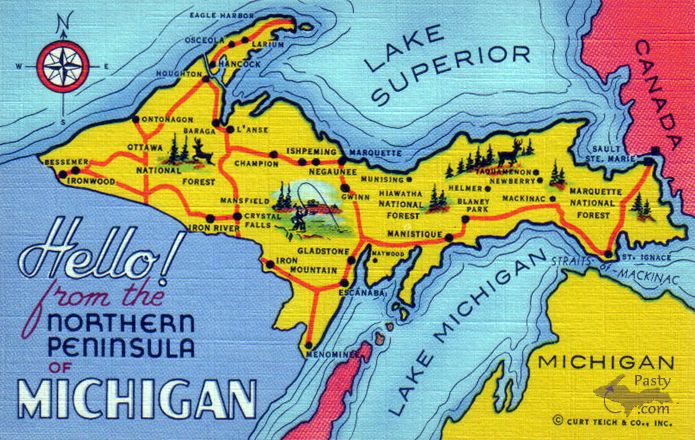
My earliest memories of the U.P. are tied to a colorful postcard with a cartoon quality... tiny images of fishermen reeling in the big one... deer cavorting in the pine trees... and curving highways connecting the dots in this land of enchantment. Today's Shoebox Memory from Marsha Galbraith captures those qualities in this famous Curt Teich and Co. masterpiece. The company, based in Chicago, was active from 1898 to 1978 creating postcards related to regional travel or American products. Of particular interest is the Keweenaw, where the twin cities of Calumet and Laurium appear instead as "Osceola" and Laurium.

In its time, Curt Teich and Co. produced over 365,000 postcards. In the What'sUP section this month we've been reminiscing about the Pasty Cam's beginnings back in 1998, publishing a picture a day for the past 8+ years. Only another 2,992 years at this rate to catch up with Curt Teich :^O

By the way, there is a museum in Wauconda, Illinois which houses the Curt Teich Archives, among which I'm sure you'll find several other Northern Michigan postcards - as well as every other subject in America.

Have a good week :o)


By Deb S. (Usedtobeayooper) on Sunday, March 19, 2006 - 09:05 am:

Great picture! I have a map something like that hanging on my wall only it says "Map Showing Lighthouses of the Great Lakes". So it actually has all of the Great Lakes. The only "GREAT" one is Superior in my book though. Anyway, just thought I'd mention that. I just love that wall hanging since I'm a lighthouse fanatic as well as a great lake fanatic. Good Sunday morning to all!


By Margaret, Amarillo TX (Margaret) on Sunday, March 19, 2006 - 09:35 am:

You've cut off the nose--Ashland.


By james f. haven (Technoido) on Sunday, March 19, 2006 - 10:07 am:

Look carefully. It's spelled Larium
Plus I guess we are technically, the Northern Peninsula of Michigan,
but what an almost quaint way of putting it. and where did the tip
of the Keweenaw go? Hey, any map at all tells a story. And they're
all good stories.


By Ellen Hass (Ellenm) on Sunday, March 19, 2006 - 10:45 am:

Where is M 28? Does anyone know when 28 was completed between Newberry and Munising?


By JOHN AND ANNE KENTUCKY (Username) on Sunday, March 19, 2006 - 10:53 am:

Is there a book out there about UP postcards? By the way usedtobeayooper, Lake Michigan not great?Come on....


By allen philley (Allen) on Sunday, March 19, 2006 - 11:29 am:

Keweenaw Co. Hist. Soc. has a book of historical post cards. look on the lower left of the pasty.com home page.


By WishingIWasInDaUP (Sur5er) on Sunday, March 19, 2006 - 11:47 am:

Love the old postcard...my daughter used to collect postcards from our travels to the UP...and at one time had an entire wall of her bedroom covered in UP postcards :)
Seems strange to hear the UP referred to as the "Northern Peninsula". Anyone know when they started referring to it as the UP?
John and Anne Kentucky: I agree with you, Lake Michigan is great...because when I stick my feet in Lake Michigan, I love the idea that its waters also touch the UP...which makes it great in my book ;)


By Deb S. (Usedtobeayooper) on Sunday, March 19, 2006 - 12:24 pm:

John and Anne, Didn't mean to ruffle any feathers. It's just that I lived on Lake Michigan for one whole summer, and while the kids and I loved it cuz it was much warmer and you could swim in it longer, it just wasn't the same. When we went "home", we would go to Superior where you can ALWAYS see bottom because it's so fresh and clean. Granted, it's cold, but it's beautiful. I think the rest of them are beautiful too, but Superior is so fresh and clean you can't help but be in awe of it.
Sur5er, I don't know about it being called the Northern Peninsula, but I've always known it as the UP. Furthermore, my dad's feathers get ruffled when it's referred to as the Keweenaw rather than the Copper Country. It's always been the Copper Country to us and probably always will be. Don't know why it got changed. Anybody have any ideas on that? My dad was even interviewed by one of the Gazette writers and everything about this subject. The Copper Country is near and dear to his heart and he can't stand hearing it called the Keweenaw. It was a great article actually. We still have it.


By Deb S. (Usedtobeayooper) on Sunday, March 19, 2006 - 12:25 pm:

I guess M28 doesn't count, eh? Kind of strange I think.


By Deb S. (Usedtobeayooper) on Sunday, March 19, 2006 - 12:27 pm:

Sur5er, My son used to go to a little antique shop in Stillwater, MN to see if he could find old postcards from the UP. He found a few and was always thrilled when he came across some and read what was said on it. He quit that for some reason though. Some of them were pretty cool.


By WishingIWasInDaUP (Sur5er) on Sunday, March 19, 2006 - 12:51 pm:

Usedtobeayooper, Yep...my daughter quit collecting the postcards too, as she got older ...I could never figure out why, though.
Now if we're talking favorite Great Lakes, then Lake Superior, is the best ;)
In regards to Lake Michigan, it is rather clear on days that the lake isn't rolling...and all that sand is being stirred up. I love taking my jet ski way out on the lake, where you can actually look down and see the fish swimming. But most definately, not as clear as Lake Superior.
What part of Lake Michigan did you spend your summer?


By Deb S. (Usedtobeayooper) on Sunday, March 19, 2006 - 01:01 pm:

Sur5er, I spent a summer in the Escanaba/Gladstone area. It was beautiful and I loved the lake because we swam every day for hours and didn't get cold. And you're right, a better way of putting it is my "favorite" Great Lake. Because I do love the rest of them too. I boated (is that right?) out to Washington Island (I think it was) in Green Bay (not the city but the bay), and the lake just wasn't as clear as Lake Superior. But I'm sure there are days when you can see down to the bottom. Aren't we lucky to live near such gorgeous lakes?


By Kelly Marshall (Kelly) on Sunday, March 19, 2006 - 01:10 pm:

In the 1940's and 50's we we usually called The Northern Peninsula". Every now and then you would hear "Keveenaw" pronounced with the "v" sound that was a reference to the Native American heritage. So I guess now it is Keweenaw to be more historic. I felt badly when the historic Calumet sign with an Indian chief's head and a peace pipe on it, was taken down and replaced with a very plain sign. After all, Calumet means "peace pipe", what could be more historically correct?


By JOHN AND ANNE KENTUCKY (Username) on Sunday, March 19, 2006 - 01:12 pm:

usedtobeayooper,nothing ruffled,no problems.I guess we all get a little possessive about our lakes. While I admit the clarity of Superior is the best,I will always remember the cool blue green color Michigan had by the dunes.It is a neat view on top of the dunes ,with the steel mills and Chicago in sight,looking over the many shades of the lake.


By JARMO ITÄNIEMI (Japei) on Sunday, March 19, 2006 - 01:33 pm:

Hello MARSHA! So magnificent album - wonderful beatiful pictures all!!!


By FRNash/PHX, AZ (Frnash) on Sunday, March 19, 2006 - 01:42 pm:

Margaret, Amarillo TX (Margaret):
"You've cut off the nose--Ashland."

Cut off Ashland ... from a map of the UP of Michigan?
Huh? Last I knew, Ashland was in Wisconsin -- at least 20 miles west of the tip of the rabbit's nose, as the crow flies.


By Richard L. Barclay (Notroll) on Sunday, March 19, 2006 - 02:36 pm:

Another bit of trivia on the GREAT lakes, when I sailed on the freighter "C.J. Callaway' we made it a point to fill our freshwater holding tank in the middle of Lake Superior except for a few trips when we went to saltwater on the seaway for some Canadian ore and couldn't quite make it back it would be in the middle of Lake Huron. None of the others were clean enough that they required minimum treatment. If I remember correctly we flushed out the Huron water with Superior a day later.


By Daveofmohawk (Daveofmohawk) on Sunday, March 19, 2006 - 02:47 pm:

Usedtobeayooper: If you look at the map Houghton and Hancock are part of the Keweenaw Peninsula along with Keweenaw Bay. During the 80's when Bob Skugan was executive director of the Chamber and Tourism Council he came up with "The Keweenaw" as a promotional name for the entire area's tourism industry; thus was the end of "The Copper Country". Calling Houghton and Hancock the Keweenaw is still a sore spot with a lot of Keweenaw County residents.


By Marsha, Genesee/Aura (Marsha) on Sunday, March 19, 2006 - 03:06 pm:

Was surprised to get a phone call just now from Minneapolis telling me my postcard was chosen for today and to see a compliment from Finland! Actually, this postcard (and many other similar pieces of memorabilia) were given to me by my brother-in-law in Minneapolis.


By Shelley Trowbridge (Shelleyt36) on Sunday, March 19, 2006 - 03:25 pm:

Can anyone tell me what's with Mackinac being so far inland in the UP on the postcard? Did there used to be a town of some sort in that area by that name? Just curious! Oh, it's starting to feel like spring here in the middle of the mit, just a bit and I can't wait. Those 60 degree days we had last week sure gave me a bad case of spring fever!


By Deb S. (Usedtobeayooper) on Sunday, March 19, 2006 - 03:32 pm:

Richard, Ain't it the truth? I'm not a bit afraid to drink right out of Lake Superior when I'm swimming in it. You may get a little sand, but who cares? It's clean enough for me. I wouldn't do that when swimming in Lake Michigan.
Daveofmohawk, My dad lives in Lake Linden and it's still a sore spot for him that it's no longer called the Copper Country. It's a bit of our history to be called that and it's unreal that they call it the Keweenaw just because of the Peninsula. My uncle has a camp down from Freda on the lake and it makes him mad too.


By maija in Commerce Township (Maija) on Sunday, March 19, 2006 - 03:58 pm:

When I was a kid, it was the northern peninsula, but it was the "lower" peninsula, not "southern"! Going "up north" in those days meant to the northern peninsula, although you heard "upper" peninsula as well. Can't remember hearing "UP" back then. Now, people say "up north" to mean the northern lower peninsula. I, of course, always carefully say "northern lower peninsula." You're not "up north" till you cross the Mighty Mac.
It was ALWAYS the Copper Country. "Keweenaw" was where you went when you were in Calumet and went for a drive.


By eugenia r. thompson (Ert) on Sunday, March 19, 2006 - 04:06 pm:

Is that a crack I see in the ice just out from the trees near the Ramada Inn (on BridgeCam)?


By Seismic Pirate (Marc) on Sunday, March 19, 2006 - 04:22 pm:

Shelly,
It appears that they made several mistakes if you look closely. Somehow they mixed up Mackinaw with Eckerman Corner at M28 and M123. I drove thru both places about a month ago and neither had moved :)


By Seismic Pirate (Marc) on Sunday, March 19, 2006 - 04:40 pm:

I must say that I'ma amazed at the strength of everyone's feelings over "Keweenaw" vs "Copper Country".

After working with the wonderful people at Keweenaw Bay Indian Community for 2 1/2 years, I feel it necessary to remind everyone one that the area we are talking about was named "Keweenaw" a long, long time before any of us or our ancestors were living here. That should hold true for everything North of head of Keweenaw Bay, which geographically defines the Keweenaw Peninsula.

Keweenaw means "crossing place", or "portage", in the Ojibwa language.


By JAD, Oscar, MI (Jandalq) on Sunday, March 19, 2006 - 06:25 pm:

I have a "Highway Map of the Upper Peninsula of Michigan" distributed by the Upper Peninsula Development Bureau, Marquette, Michigan. It is not dated. I found it among my dad's belongings and I date it around 1940, give or take a few years. The PAVED ROADS shown are: between Ironwood and Bergland, Greenland to Ontonagon, Hancock to Eagle Harbor, Menominee to Iron Mountian via Powers. Powers to Rapid River, Rapid River to M77 and a very short distance through Naubinway, M35 from Gladstone to Gwynn, A short section near Michigamme, Ispeming to Marquette, M94 from south of Skandia over to Munising, a short section near Trout Lake, a short section near Rudyard, and a few miles South and west of the Soo, a short section east of Newberry. M28 was unpaved from Munising to the Soo except for that short section. M95 from just north of Iron Mt. up to US 2 is not on the map. An unpaved road known as M45 is shown instead. 75 south of the Big Mac isn't there, and the roads south are unpaved until you get close to Petosky.


By Richard L. Barclay (Notroll) on Sunday, March 19, 2006 - 06:59 pm:

It is a little late to continue today's thread on Copper Country vs Keweenaw but do your relatives that dislike calling it Keweenaw allow that the CC extends down toward Mass and Ontonagon and include that area? I've always considered that CC was more inclusive of that area and Keweenaw was as Seismic Pirate (Marc)described it. I believe the last working mine was White Pine which would seem to include that area.


By Seismic Pirate (Marc) on Sunday, March 19, 2006 - 07:16 pm:

White Pine was the last working copper mine in the area, loosing its bid to start up solution mining, several years ago, due to, I believe, protests over the transportation of the sulfuric acid needed to suspend the copper in solution.
It might not be the last, however. There is a renewed interest in the metallic minerals present in the "area" :) Nickle sulfide mining in the central UP is just about a done deal, already, and the "area" is currently being re-explored...


By Deb S. (Usedtobeayooper) on Sunday, March 19, 2006 - 07:38 pm:

Yes Richard, they do include that area. They consider any part of that area that mined copper the Copper Country. I'm sure part of the problem is that these people don't like change. They're in their late 70's and early 80's and the change offends them. I personally don't care if it's called the Keweenaw. It's just not what it was while I was growing up. But some of the older folks just don't like the change being made and I think the people who live in Keweenaw County dislike the change more than anybody. But as I said, I really don't care. The country's beautiful no matter what it's called.


By Deb S. (Usedtobeayooper) on Sunday, March 19, 2006 - 07:57 pm:

Oh and Richard, you're the first person, besides myself, who I've heard Mass called "Mass" rather than "Mass City". Change is hard, isn't it? It just seems wrong to call it "Mass City" somehow. Just like Tamarack was always "Tamarack" and now they just expect us to call it "Tamarack City". I still call it "Tamarack". LOL I must be getting older. Every time we drive through those towns I get a kick out of it.


By Walter P McNew (Waltermcnew) on Sunday, March 19, 2006 - 08:10 pm:

the people of this area are anishinaabe which is in the algonquin lingural group also found through the upper midwest the east and canada. out of respect to these native americans we certainly use the word keewenaw as they are the ones who named it, and after all everybody deserves respect. who would it be who says they are not.


By Seismic Pirate (Marc) on Sunday, March 19, 2006 - 08:12 pm:

My four year old daughter calls Mason, "Town of Mason". I used to live in Tamarack and as we drove from Tamarack to anywhere, I would recite the cities, towns and villages as we drove thru. I must have told her, "this is the town of Mason". Anyway, its cute the way she says it and I doubt it would offend anyone:)
Come to think of it, I call Tamarack just that, but my daughter says Tamarack City. Must have got that from my wife...


By Seismic Pirate (Marc) on Sunday, March 19, 2006 - 08:23 pm:

Correct a mundo, Walter. I was taught that they migrated West from Eastern Canada, to the meeting place, which is near or at the Soo. From there, some migrated further West, looking for a particular place they were told to find. The Keweenaw resembled that place, had good fishing and hunting so they settled there.

And yes, they certainly deserve our respect and we should honor the area with its original name, I believe, although I suppose I interchange Keweenaw, Copper Country and God's Country, frequently.
Whatever the case, like Dorothy said, "There's no place like home".


By a m hill (Lvcamnotes) on Sunday, March 19, 2006 - 09:37 pm:

deb s.
i'm gonna date myself but in the early 50's
i've always heard mass city instead of mass ->
yet road signs always said mass.

i grew up in hancock-houghton area and
always considered hancock-houghton, c-l-k
as copper country -- and that would include
lake linden and surrounding area.

i'm surprised by your and richard's suggestion
that copper country extends sw to mass and
white pine.

although i don't know anything of mass:
i thought that white pine was a recent copper
mine that opened and closed and doesn't have
anything to do with the 'copper country.'

love all of up


By Inwis (Inwis) on Monday, March 20, 2006 - 12:13 am:

The property at White pine was bought by The Copper Range Company at auction on the steps of the Ontonagon county court house in May 1929 for about $115,000.
But probably because of the depression, I think they first mined the property in about 1937 or so?
Calumet and Hecla owned much of the land and mined there as early as the first world war or sooner.


By Seismic Pirate (Marc) on Monday, March 20, 2006 - 12:24 am:

Hey Inwis,
Did you get the info on natural wall?


By Inwis (Inwis) on Monday, March 20, 2006 - 12:33 am:

Seismic Pirate (Marc).
Gee.. yes I did just.. a minute ago. Thank you very kindly..


By Russell E. Emmons (Russemmons) on Monday, March 20, 2006 - 01:24 am:

Here is one I have from the early 60s (no zip code!) Says on the back Hiway completed Sept. 17, 1960. Gallaghers Studio Duluth Minn.

As a boy in the 40s and 50s traveling back and forth to the Copper Country from Troll Land, as I recall parts of M28 and other state hiways up there were still gravel roads!

1,Lakecirclerouteimg11gbh


By Russell E. Emmons (Russemmons) on Monday, March 20, 2006 - 01:31 am:

OOOPS! got canceled, trying again!

Lakecirclerouteimg11gbh


By WishingIWasInDaUP (Sur5er) on Monday, March 20, 2006 - 02:33 am:

Thanks for the map, Russell. It's amazing how many towns there are now, in the UP, compared to when this map was made.


By Mary Ellen Perkins (Gonecamping) on Monday, March 20, 2006 - 10:10 am:

As to whether the Ontonagon County area should be considered part of the Copper Country, perhaps we can agree that the pasty.com Reflections site certainly includes this area. The Adventure and Mass Mines in the Mass-Greenland area were certainly part of the copper boom. And frankly, the Ontonagon Boulder found near Victoria along the Ontonagon River--well known in ancient times by native Americans, and a source of intense interest by Alexander Henry and copper speculators and prospectors--was what initially fueled the copper rush.


Powered by:  
Join Today!
Each day the Pasty Cam has 2 areas to post messages: 
  • Cam Notes - comments related to today's picture and discussion
  • What'sUP - other topics, conversation and announcements
  • *** Please use the appropriate forum ***
    Here's a list of messages posted in the past 24 hours
    See our guest photo gallery for more great views from the U.P.

    Add a Message


    A user/password combination is now required to post messages to Cam Notes. Registration is free. Click here to register or maintain your I.D.
    Username:  
    Password:

    Home | Pasty Cam | Contest | Order Now | Bridge Cam | Past-E-Mail | GP Hall of Fame | Making Pasties | Questions