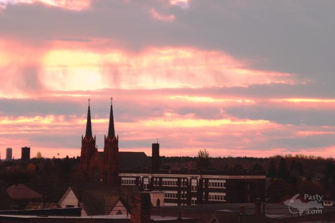
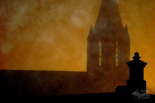
I wish I had the time or maybe an app that would count exactly how many photos have appeared on the Pasty Cam in the past 19 years. I truly wouldn't be able to guess the number, but I know it's up there in the thousands. Photos like the first two here today from Dan Brown, snapped in Calumet, with the skyline colored in pink. It looks like he managed to get up on a rooftop in town, which really emphasizes the church spires from St. Paul the Apostle Church, a chimney and even what looks like the Swedetown landmark water towers off in the distance. Dan's second photo is another Calumet steeple, I think from St. Anne's Church as you come on to 5th Street in Calumet. Now known as the Keweenaw Heritage Center.
So many of the churches here in the Copper Country are built with Sandstone from the area, mostly referred to as Jacobsville Sandstone, from the quarry out there. Today's current photo is what this beautiful rock looks like in its natural state, on the shores of Lake Superior. Joy Ziemnick was exploring recently on the Gay/Lac La Belle road when she snapped this beauty.
Interesting enough, when looking for a video to accompany today's photos, one of St. Paul the Apostle Church caught my eye, recorded by a well known photographer throughout the years on these pages, Steve Brimm. Enjoyable not only for the bird's eye view of the church and surroundings, but the music is calming and holy at the same time. Sit back and enjoy the flight!
By Alex "UP-Goldwinger" (Alex) on Tuesday, May 23, 2017 - 10:27 am:
Neat-o pix, especially 2017 shoreline. I liked how the angle of the camera curved the steeple towers in the video, I felt like I was at a galactic funeral on Krypton.
By D. A. (Midwested) on Tuesday, May 23, 2017 - 03:31 pm:
Alex,
Curvature? No else sees any curvature Alex. Your eyesight is getting to you. Maybe get your computer checked out?
By Deb S. (Usedtobeayooper) on Tuesday, May 23, 2017 - 05:30 pm:
Totally spectacular pictures!!
By D. A. (Midwested) on Tuesday, May 23, 2017 - 07:48 pm:
Interesting fun fact about Jacobsville Sanadstone. The Keweenaw Fault Line runs down the middle of the Keweenaw Peninsula. It creates most of the wonderful water falls on the south facing cliffs like Houghton Douglas, Hungarian and Haven Falls. This fault line is also the general separating point of the Sandstone to the south of it and the Basalt lava flows generally to the north of it.
Eventually the fault line exits the Keweenaw and dives deep into Lake Superior. It re-emerges from the Lake near Munising and is the separating line of great geologic significance. At one point the volcanic action was so powerful they say the North American continent almost ripped in half.
So exactly where does the Keweenaw fault exit the peninsula? If you are on a boat just off the point of land east of Bare Bluff, between Fisherman's Cove and The Montreal River delta you can distinctly see the fault line on the shoreline. I took the picture below and added notes showing the Red Sandstone to the left and black Basalt (mostly called Copper Harbor Conglomerate) to the right.
DA, I see a bit of a curve illusion as well in the Video.
Alex, what's wrong with your eyes? He said, I don't know, I said, let me give it a try! But we just smiled and waved... sittin there on that sack of seeds!! lol That's the story of the Wildwood weed!!
By D. A. (Midwested) on Wednesday, May 24, 2017 - 12:43 am:
Uncle Chuck,
Shhhhhh.
By the way, the 2009 sky looks a bit like Jacobsville Sandstone.
By Thomas Baird (Thomas) on Wednesday, May 24, 2017 - 04:28 am:
The double church steeple is awesome, and like the shoreline.
By Alex "UP-Goldwinger" (Alex) on Wednesday, May 24, 2017 - 07:43 am:
You guys pull'n my chain or should I be cut'n back on the meds? :-)
By Capt. Paul (Eclogite) on Wednesday, May 24, 2017 - 07:57 am:
Copper Harbor Conglomerate is a sedimentary unit composed of rift filling redbeds from the former supercontinent Rodinia. The basalts in the shoreline photo are of the Portage Lake Volcanics, common throughout the area. In addition, the shoreline photo is just one example of where the Keweenaw Fault goes offshore. East of Lac La Belle, the Fault zig-zags back and forth until finally jutting off into Lake Superior near Fish Cove.
By Capt. Paul (Eclogite) on Wednesday, May 24, 2017 - 07:59 am:
Cut back on the meds and have more single malt, Alex; tis better for ya anyway! ;-)
By Alex "UP-Goldwinger" (Alex) on Wednesday, May 24, 2017 - 09:06 am:
Indeed Captain. Thanks for the clarification. While the final exit is near the tip of the point west of Fish Cove before you get to the Montreal River my picture is an example taken a bit further west, closer to Bete Grise. The aggregate rock in the conglomerate is basalt though. It's what is predominate on the shorelines further east, very visible in places like High Rock Bay.
Alex, I should have tried that closer to April 1.
By D. A. (Midwested) on Wednesday, May 24, 2017 - 03:10 pm:
can you say "sandstone shore" 5 times fast?? ;)
By D. A. (Midwested) on Wednesday, May 24, 2017 - 10:27 pm:
Keweenaw Peninsula and Keweenaw Fault Line
By D. A. (Midwested) on Wednesday, May 24, 2017 - 10:29 pm:
Close up of Fault Line near Bete Grise and Montreal River
Powered by:
You are welcome to comment here or on Pasty Central's Facebook page Here's
a list of messages posted in the past 24
hours See our guest
photo gallery for more great views from the U.P.