May 20-15

Past-E-Mail: Cam Notes - 2015: May: May 20-15
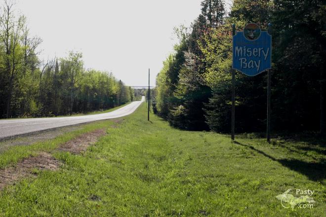
Misery Bay road    ...scroll down to share comments
Photos by Mary Drew
Misery River    ...scroll down to share comments
Photos by Mary Drew
Flowing into Lake Superior    ...scroll down to share comments
Photos by Mary Drew
Lakeshore erosion    ...scroll down to share comments
Photos by Mary Drew
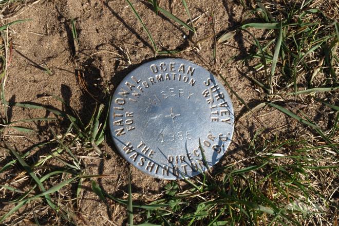
Survey marker    ...scroll down to share comments
Photos by Mary Drew
Porcupine up a tree    ...scroll down to share comments
Photos by Mary Drew
Shoe tree    ...scroll down to share comments
Photos by Mary Drew


By
Mary Drew at Pasty Central (Mdrew) on Wednesday, May 20, 2015 - 07:53 am:

The road to Misery Bay is quite scenic as it slopes down and Lake Superior can be seen off in the distance. Once you arrive at the parking area on the banks of Misery River, you know the drive there was worth it. The signage at the boat launch there on the river right before it empties into the Big Lake, says that this area was once a safe haven for nomadic people. Then later a fishing site for bands of Lakota and Anishinabeg. In 1765 a colonist Englishman, Captain Jonathon Carver explored here, so on early maps the area is called Carver Bay after him. From the 1840's to the 1860's the small town of Franklin was established here with a port for shipping copper, by a Frenchman named Artault. That mining attempt failed, so only timber logs were later rafted to sawmills from this location. Then in the 1890's onward, Finnish settlers from a nearby area known as, Riihi-Kontri did some commercial fishing from this spot and would also have picnics and gatherings here to celebrate their midsummer Juhannus. So the area has quite an interesting history.

It sure is a beautiful location on the shores of Lake Superior and on this day, the wind was whipping the Big Lake into wavy, whitecaps as we walked along the beautiful sandy beach there. There are few, if any rocks on the beach, but plenty of fallen trees, logs and driftwood around. The only thing we left with as a souvenir of our visit there, was a wood tick on my hubby's neck. We promptly left him on the road on our return trip.

Speaking of "on the road" there, we found a number of interesting things along the way. One was the Survey Marker right there at the parking area by the banks of the Misery River. Next we saw a porcupine along the side of the road, up in a small tree. We figured it was dining on the new greenery that was sprouting. As soon he noticed me snapping pictures of him, he slowly crawled down and off into the woods he ambled.

The last photo is the famed "shoe tree" and we were lucky to catch it in full bloom, with a variety of shoes and boots already there on the branches. I didn't take the time to count them, but I did note the majority were tennis shoes, with a few pairs of hiking boots sprinkled in and even a pair of cowboy boots had sprouted already.

All in all, our first visit to Misery Bay was a big success. It was nice to see the beauty of that area in person, whereas I'd only enjoyed it in photos from others before.


By Capt. Paul (Eclogite) on Wednesday, May 20, 2015 - 07:55 am:

Not sure why it's called "Misery Bay", looks like a pretty nice place to me......


By Deb S. (Usedtobeayooper) on Wednesday, May 20, 2015 - 08:13 am:

I love Misery Bay. It's such a great place to go
swimming. And that shoe tree very nearly made me
spit out my coffee! Thanks, Mary!!


By Richard J. (Dick_fl) on Wednesday, May 20, 2015 - 08:17 am:

Jingo Viitala talks about Misery Bay in this video. https://www.youtube.com/watch?v=1EtUx5HKG4w


By Janie T. (Bobbysgirl) on Wednesday, May 20, 2015 - 08:49 am:

Interesting picture of the Porcupine!


By Alex "UP-Goldwinger" (Alex) on Wednesday, May 20, 2015 - 08:51 am:

Excellent pix...another must-see when I'm UP there.


By Donna (Donna) on Wednesday, May 20, 2015 - 09:01 am:

That is SO interesting!! Thank you Mary and Jim!
Decades ago, I worked at the Holiday in Hancock and
my boss and I went out to Misery Bay to visit with an
old Finnish gent that came in almost daily to "fill
er full"....he took a spin all the time....and we
went out on a Sunday afternoon...and had all the Finn
amenities...coffee and sweets...and then he took us
to his "Museum" which was an out building with some
of the most interesting things I'd ever seen.

And that entire area is stunning!


By JoAnne Stefanac (Davejostef) on Wednesday, May 20, 2015 - 09:26 am:

So funny, when I first looked at that porcupine pic, I THOUHGT I was looking at some kind of Bigfoot sighting. LOL


By Duane P. (Islandman43) on Wednesday, May 20, 2015 - 09:29 am:

Great pictures, it sure is nice seeing sand on the beach instead of snow. Never been there but it looks like a nice area. When I first glanced at the thumbnail pic of the porcupine I thought..Oh my gosh. Someone saw a sasquatch.


By mickill mouse (Ram4) on Wednesday, May 20, 2015 - 09:36 am:

so many places I would love to see now that we are living here and have the time to explore.


By jbuck (Jbuck) on Wednesday, May 20, 2015 - 01:18 pm:

Porcupine? Looks like sasquatch walking thru the woods to me!


By Dan N. (Daninca) on Wednesday, May 20, 2015 - 02:36 pm:

Nice pictures Mary. Now I'm really homesick. Having grown up in Toivola, I spent a lot of time at Misery Bay, and Agate Beach. We used to ride our bicycles down the Misery Bay Road, (we could coast almost the whole way), coming back up was tough! (even when I was a young buck) We also walked, (or ran) from Agate Beach to the mouth of the Misery River along the beach. I was a 'beach bum' back in those days. Hope you stopped for a cold drink of the artesian spring water from the pipe by the old Misery Bay School. Thanks for the memories.


By Thomas Baird (Thomas) on Wednesday, May 20, 2015 - 04:00 pm:

Great photos.


By Just me (Jaby) on Wednesday, May 20, 2015 - 06:03 pm:

I wonder why it was named Misery Bay? Great pics. i
now know where to go for new-er shoes.


By Duane P. (Islandman43) on Wednesday, May 20, 2015 - 07:34 pm:

After much searching this is all I could find on Misery Bay.

Fed by the Misery River, the reasons behind both the river’s and bay’s names are unclear, although one version says that the settlers there were miserable because they had trouble receiving supplies. Another origin story says the place is named for the Misery Indians, a branch of the Chippewa or Ojibway tribe.


By Alex "UP-Goldwinger" (Alex) on Thursday, May 21, 2015 - 07:25 am:

My theory is that a cunning resident came up with that name to keep the crowds away.


By kosk in Toronto (Koskintoronto) on Thursday, May 21, 2015 - 06:46 pm:

I'm thinking it had something to do with mosquitoes. I love the
place.


By Doug Smith (Smitty) on Thursday, May 21, 2015 - 07:09 pm:

Looks like you caught a glimpse of the elusive yooper bigfoot!


Powered by:  
Join Today!
Each day the Pasty Cam has 2 areas to post messages: 
  • Cam Notes - comments on today's picture and what's on your mind
  • What'sUP - a view of previous year's and invitation to:
  • Pasty Central's Facebook page
    Here's a list of messages posted in the past 24 hours
    See our guest photo gallery for more great views from the U.P.

    Add a Message


    A user/password combination is now required to post messages to Cam Notes. Registration is free. Click here to register or maintain your I.D.
    Username:  
    Password:

    Home | Pasty Cam | Contest | Order Now | Bridge Cam | Past-E-Mail | GP Hall of Fame | Making Pasties | Questions